| |
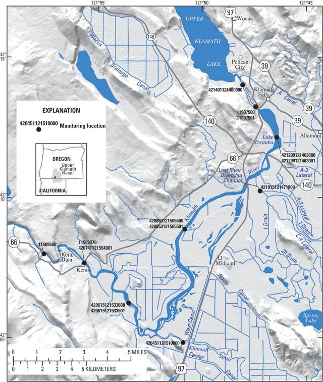
Water-Quality Monitoring in the Keno Reach of the Klamath River
Bureau of Reclamation
personnel deployed 12 water-quality instruments that measure water
temperature, dissolved oxygen, pH, and specific conductance every hour
at 8 sites in the Keno reach of the Klamath River. In addition, the
USGS monitors streamflow and measures
water temperature below both the Link River Dam and the Keno Dam.
These data are available and can be accessed by clicking on
the site identification number in the map below, or by selecting a site
from the table below the map. These links will take you to the USGS
Data
Grapher, where you can create custom graphs and tables of data and
compare data within and among sites.
Alternatively, the data may be accessed by selecting a site from the
table below:
| Site Name |
Site ID |
Parameters |
| Upper Klamath Lake at Link River Dam |
421401121480900 |
T, DO, %Sat, pH, SC, sd |
| Link River at Klamath Falls, OR |
11507500 |
Q, T |
| Link River below Keno Canal |
11507501 |
T, DO, %Sat, pH, SC, sd |
| Klamath River at RR Bridge at Lake Ewauna [top] |
421209121463000 |
T, DO, %Sat, pH, SC, sd |
compare top
and bottom |
| Klamath River at RR Bridge at Lake Ewauna [bottom] |
421209121463001 |
T, DO, %Sat, pH, SC, sd |
| Lost River Diversion Channel near Klamath River |
421015121471800 |
T, DO, %Sat, pH, SC, sd |
| Klamath River at Miller Island Boat Ramp [top] |
420853121505500 |
T, DO, %Sat, pH, SC, sd |
compare top
and bottom |
| Klamath River at Miller Island Boat Ramp [bottom] |
420853121505501 |
T, DO, %Sat, pH, SC, sd |
| Klamath Straits Drain near Hwy 97 |
420451121510000 |
T, DO, %Sat, pH, SC, sd |
| Klamath River at Site KRS12a nr Rock Quarry [top] |
420615121533600 |
T, DO, %Sat, pH, SC, sd |
compare top
and bottom |
| Klamath River at Site KRS12a nr Rock Quarry [bottom] |
420615121533601 |
T, DO, %Sat, pH, SC, sd |
| Klamath River above Keno Dam nr Keno, OR [top] |
11509370 |
T, DO, %Sat, pH, SC, sd |
compare top
and bottom |
| Klamath River above Keno Dam nr Keno, OR [bottom] |
420741121554001 |
T, DO, %Sat, pH, SC, sd |
| Klamath River below Keno Dam at Keno, OR |
11509500 |
Q, T |
| where |
Q | = flow |
| T | = water temperature |
| DO | = dissolved oxygen |
| %Sat | = oxygen percent saturation |
| pH | = pH |
| SC | = specific conductance |
| sd | = sensor depth |
|
