Oregon Water Science Center
Valley Segments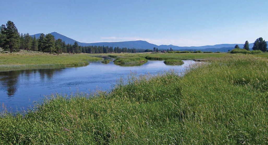
Kamkaun Spring reach of the Sprague River. (Photograph by Jim O'Connor, USGS) The main-stem Sprague River corridor can be divided into nine valley segments on the basis of the overall geomorphology of the Sprague River basin and associated valley and flood-plain characteristics. Additionally, the reaches of the North Fork Sprague River and South Fork Sprague River within the study area each constitute defined valley segments. The lower 24 km of the Sycan River has been divided into two segments—the steep and confined Coyote Bucket valley segment where the river cuts through the Basalt of Knot Tableland, and the less confined Lower Sycan valley segment downstream to its entry onto the Sprague River flood plain. Distinguishing valley segments provides an analysis framework for evaluating conditions and processes relative to overarching controls such as slope, confinement, history, and materials. If defined valley segments correspond with process regimes, segment-specific understanding can enable more efficient and targeted management for ecologic objectives. The main criteria for defining valley segments are valley confinement, major confluences, and channel slope. Current channel and flood-plain morphologic conditions, as summarized in the following accounts of individual segments (table 2; figures 16, 17, and 18) were assessed primarily from mapping based on year 2000 aerial photographs and the 2004 LiDAR. Chiloquin CanyonThe Chiloquin Canyon valley segment (figure 19) extends from near the historical Braymill mill site at FK 11.4 to the confluence between the Sprague and Williamson Rivers. The town of Chiloquin occupies a terrace, of either Sprague or Williamson River origin, north of the Sprague River flood plain. The upstream end of the valley segment is marked by the substantial slope change at FK 11.4, 1.2 km downstream of Braymill at FK 12.6 (figure 17). Most of this segment is tightly confined by upfaulted volcanic rocks (figure 16), resulting in a narrow flood plain (mean width 99 m) containing a steep (slope 0.00195) boulder- and cobble-bed channel (figure 19). Multiple terrace levels, as high as 45 m, locally flank the flood plain. This reach is the steepest of all the main-stem Sprague River valley segments, probably reflecting local tectonic uplift and tilting. The low-flow channel averages 37.8 m wide, occupying about 40 percent of the geomorphic flood plain (figure 18). Channel sinuosity is low at 1.06, as measured relative to the flood plain centerline. The flood plain has a mixed vegetation cover of herbaceous vegetation, shrubs, and ponderosa pine with local cottonwood and aspen. A part of this valley segment is flanked by County Highway 858, which locally encroaches onto the flood plain between FK 9.5 and 11.4. The channel was also affected by Chiloquin Dam at FK 1.3 (figure 19B), a water supply diversion structure constructed in 1914 and removed in August 2008. A bridge formerly spanned the flood plain and channel at FK 0.7. This valley segment contains USGS gage 11501000 Sprague River near Chiloquin, Oregon, at FK 8.3, which has been at this location since 1931, continuous with a previous location upstream at FK 28.6 since 1921. An earlier gage at about FK 0.7 near the town of Chiloquin (figure 20) had continuous records for the period 1912–1919, with occasional measurements through 1925 (USGS Oregon Water Science Center, Portland, Oregon, measurement station records for station 11502000, Sprague River at Chiloquin, Oregon).Near the upstream end of the valley segment, Medicine Rock Cave (Archeological site 35KL8; near FK 10.9) was noted by Spier (1930, p. 14) as near the location of the site of the Klamath “First Sucker Ceremony” celebrating the annual spring migration. As noted above, this site contained evidence of fluvial deposition soon after the Mazama eruption (Cressman, 1956) that we attribute to the Sycan flood. Substantial sucker spawning has been observed in recent years between FK 0 and 1.2 at the lower end of this valley segment (Ellsworth and others, 2007). BraymillThe Braymill valley segment is also a narrow canyon segment (figure 21) but is distinguished from the Chiloquin Canyon valley segment by its much flatter gradient—0.00024 compared to the 8-times-steeper slope of the Chiloquin Canyon segment (figure 17, table 2). The Braymill valley segment extends 5.8 km from the valley contraction at FK 17.2 to the slope inflection at the head of the Chiloquin Canyon segment at FK 11.4. Within this reach, the flood plain averages 110 m wide and is flanked by bedrock, colluvial slopes, narrow flood-plain surfaces, and terraces rising 10 m above the channel (figure 16). As with the Chiloquin Canyon valley segment, sinuosity is low (1.07) and the low-flow channel occupies about a third of the total flood-plain width. Vegetation within the geomorphic flood plain is also similar to Chiloquin Canyon segment: predominantly herbaceous, shrubs, and ponderosa pine. The Braymill segment is flanked and traversed by County Highway 858 and the Williamson River Road. County Highway 858 crosses the Sprague River at FK 15.5. Outbuildings and mill ponds associated with the decommissioned Braymill mill occupy the flood plain between FK 12.5 and 12.6. Kamkaun SpringThe Kamkaun Spring segment (figure 22) extends 15.2 km from FK 32.4 at the downstream end of S’Ocholis Canyon valley segment to the head of the Braymill segment at FK 17.2. This is a sinuous (1.59), low-gradient (slope 0.00015) reach flanked by broad flood plains (figure 17, table 2). The channel is typically some distance from valley margins (figure 16). This segment is locally referred to as the “Nine Mile reach.” The flood-plain and flanking main-stem valley fill are bounded by bedrock uplands and terraces up to 7 m higher than the geomorphic flood plain. The average width of the geomorphic flood plain is 500 m (figure 17), but this area of active channel migration for the last several thousand years is flanked by broad valleys and basins (chiefly mapped as main-stem valley fill; plate 1) that are also inundated during the largest floods. The Sprague River meanders through the flood plain (which in turn is quite sinuous) and has left several oxbow ponds and abandoned channels. The average channel width is about 34 m (figure 18), and the channel mostly flows on sand and gravel, but also in places flows on indurated clay and silt locally scoured into several-meter-deep holes and chutes. Former fords and irrigation diversions are marked by placed rock and coarse gravel accumulations spanning the channel. Flood-plain vegetation consists chiefly of herbaceous grasses and forbs with abundant shrubs and local tree-form willows. Several large spring complexes supplement river flow in this reach, including those at FK 32.1 (McCready Springs), 30.2 (Kamkaun Spring), 25.5 (Lalo Springs), and Whitehorse Springs, which enters the flood plain from the north at FK 22.0. Together, these springs add 1.95 m³/s to the Sprague River (Gannett and others, 2007), accounting for 12 percent of the annual flow. These spring complexes and associated pools and channels that carry flow from the springs to the river create a suite of aquatic habitats that may be important for sucker spawning and rearing, as concentrated adult sucker movement has been observed in this reach (Ellsworth and others, 2007). The reliable water source and the rarity of river freezing provided by these spring complexes in conjunction with the wide flood plains have led to a long history of settlement in this reach. Multiple archeological sites on terraces and hillslopes flanking the flood plain in this reach possibly date to more than 8,000 years ago (Spier, 1930; Cressman, 1956; Butler and others, 2010). Early homesteaders had begun cattle ranching here at about the time Frank McCready settled in 1915 on the peninsula of terrace jutting into the flood plain between FK 31.9 and 28.7 (Greg Harris, F. McCready’s grandson and present landowner, oral commun., 13 September 2007). In conjunction with the cattle ranching and flood-plain irrigation, diversion dams and ditches were emplaced within this reach by the mid-1920s (USGS Oregon Water Science Center, Portland, Oregon, measurement station records for station 11501000). Construction of the OC&E railroad to Bly and concurrent logging also proceeded through this reach in the 1920s, with the railroad grade effectively diking parts of the flood plain. More systematic levee construction and willow eradication began during 1953–54 by the U.S. Army Corps of Engineers, when levees and dikes were constructed by excavating directly from the channel (Greg Harris, oral commun., 13 September 2007). More recent channel and flood-plain modifications in this segment include filling of meander cutoffs and associated bank stabilization, and local levee breaching (figure 23). S'Ocholis CanyonThe S’Ocholis Canyon valley segment (figure 24) encompasses 15.8 km of confined canyon and narrow valley between the much wider Buttes of the Gods and Kamkaun Spring valley segments. Its upstream boundary (FK 48.2) is close to the confluence of Trout Creek at FK 48.0. Dockney Creek also enters from the south at FK 35.2. The geomorphic flood plain averages 170 m wide and is everywhere less than 500 m wide (table 2; figure 17). The flood plain is mostly flanked by steep bedrock and colluvium-mantled hillslopes, but also locally by low terraces up to 5 m above the active flood plain, and tributary flood plains and fans (figure 16). The flood plain is slightly wider between FK 39.4 and FK 43.2, where it is confined by the low terraces and where a large area of main-stem valley fill is contiguous to the geomorphic flood plain between FK 42.3 and 42.6. Within this valley segment, the channel averages 27.7 m wide, has a sinuosity of 1.12, and has a slope of 0.00027, substantially less sinuous and slightly narrower and steeper than the alluvial segments upstream and downstream (figure 18). The channel bed is primarily sand and gravel, locally colonized by dense aquatic growth during summer low flow periods. The flood plain is vegetated with herbaceous vegetation and shrubs (including locally thick willow patches, particularly in wider reaches), with some ponderosa pine and sparse aspen patches. Human disturbance has had few effects on this reach. A rock accumulation associated with an old channel crossing forms a low-flow riffle at FK 35.8. Bridges presently span the channel at FK 34.3 and 40.7. County Highway 858 flanks the channel and flood plain between FK 34.3 and FK 42.3, passing through the Lone Pine community on a low terrace north of the Sprague River at about FK 40.5. Unpaved forest tracks parallel the channel in the confined canyon reaches. Most of the flood plain in this valley segment is not actively cultivated, but is locally grazed. Buttes of the GodsThe Buttes of the Gods valley segment (figure 25) spans 9.8 km from the town of Sprague River at FK 58.0 to the head of the S’Ocholis Canyon segment near the Trout Creek confluence at FK 48.2. The upstream segment boundary is defined by the valley constriction and change in slope (figure 17 and 18) where abandoned fan surfaces sloping from the south encroach against the downstream end of the Basalt of Knot Tableland and underlying Tertiary lacustrine sediment. This expansive flood plain of this valley segment is flanked by terraces, alluvial fans and pediments, many of which are abandoned and incised (plate). The 2000 channel is within 10 m of the valley margin for less than 10 percent of its length (figure 16). The highest terraces are up to 8 m above the present channel. Large areas of main-stem valley fill, possibly inundated at high flows, occupy valleys marginal to the geomorphic flood plain. Locally, colluvium descends to flood-plain and terrace surfaces from isolated volcanic buttes and the broad mesa underlain by the Basalt of Knot Tableland north of the Sprague River. The geomorphic flood plain averages 870 m wide, with the channel averaging 35.8 m wide (figures 17 and 18). Channel slope for this valley segment is 0.00019, less than that of the S’Ocholis Canyon valley segment downstream, but distinctly steeper than the upstream Council Butte valley segment. Channel sinuosity is 2.01, greatest of all the valley segments. The channel substrate consists of patchy sand and gravel over indurated silt and clay. Ledges of this silt and clay locally form small drops at low flow stages. The induration and extensive jointing within the clay and silt indicate that this sediment is Tertiary lacustrine sediment rather than Quaternary fluvial sediment. Council ButteThe Council Butte valley segment is another wide valley segment (figure 26), which together with the Buttes of the Gods segment encompass most of what is known as the Sprague River Valley. The Council Butte segment stretches 18.8 km from the Sycan River confluence at FK 76.8 to the valley constriction and distinct channel-slope increase at FK 58.0, coinciding with the town of Sprague River and the crossing of the Sprague River by the Sprague River Road. The geomorphic flood plain averages 840 m wide, but narrows substantially near Council Butte (at FK 66.4) and near the downstream end of the valley segment where it is locally less than 100 m wide (figure 17). For much of its length, the flood plain is flanked on the north by the 70-m-high mesa underlain by the Basalt of Knot Tableland and southward descending colluvial slopes and tributary fans. The geomorphic flood plain is bounded on the south by main-stem valley fill, low terraces, active and abandoned alluvial fans, and locally by colluvial slopes and bedrock associated with Council Butte and other bedrock uplands. Incised fans emanating from Bly Mountain and surrounding uplands encroach upon the flood plain at the west end of the valley segment, narrowing the flood plain. The upstream end of this segment abuts the Sycan River flood plain as well as pumice-rich deposits of the Sycan flood. The channel within the Council Butte valley segment averages 35 m wide, is sinuous (1.70) and has a gradient of 0.00015, which, with the similarly low-gradient Kamkaun Spring valley segment, is the flattest in the study area (figures 17 and 18). The channel substrate varies from mainly sand with sparse gravel near the Sycan River confluence to patchy sand over mud and clay at the downstream end of the reach. A rocky ford spans the channel at FK 76.3, but, besides this, there is little gravel in the channel or banks. At low flow, velocity is slow and the channel is rimmed by dense sedge-rush communities, and locally several large wapato colonies. The flood plain is treeless, has very few shrubs, and is vegetated mainly by pasture grass, in places irrigated. Levees, dikes, and drier flood-plain patches are vegetated with sagebrush and grass. The Council Butte valley segment has been extensively modified by ditches, levees, bank protection, and farm road construction. The total length of such features in 2000 was 76.3 km, most of which were constructed in 1940–68 (table 6). The railroad grade, constructed in the 1920s, locally encroaches onto the southern edge of the geomorphic flood plain and flanking main-stem valley fill. More recently, as part of channel restoration efforts, meander cutoffs and secondary channels have been plugged and armored with rock and large wood near FK 61.4 and 76.2. Beatty–SycanThe Beatty–Sycan valley segment (figure 27) is a short reach extending 4.2 km from the downstream end of Beatty Gap at FK 81.0 to the Sycan River confluence at FK 76.8. Like the two downstream segments, this is a wide and unconfined reach containing a sinuous (1.68) Sprague River. This segment constitutes the upper part of the Sprague River Valley. The geomorphic flood plain averages 910 m wide (table 2, figure 17) and is flanked mostly by main-stem valley fill that is probably inundated during large floods, as well as active and incised tributary fans and flood plains. The valley of Brown Creek enters from the south at FK 80.7, adjacent to the large spring complex known locally as Medicine Springs, which contributes about 0.4 m³/s of flow to the Sprague River (Gannett and others, 2007). In total, springs in the upper part of this valley segment add about 1.6 m3/s (Gannett and others, 2007), thereby augmenting the annual flow by 18 percent from that measured just upstream at Beatty Gap (gage 11497500). The channel is chiefly flanked by flood-plain deposits, averages 29.4 m wide and flows on a slope of 0.00021 (figures 18 and 16). The channel substrate is mostly sand but is locally muddy. During the 26 June 2006 canoe reconnaissance of this reach, abundant freshwater mussels were noted in the channel bed near FK 79.2 (which has subsequently been filled and relocated as a part of channel restoration activities). The channel margin is mostly vegetated with sedges, rushes, and some grasses. Willow clumps have grown on a few point bars and along the edges of former channel routes. Otherwise, the flood plain is vegetated with pasture grass with drier parts hosting sagebrush and xeric grasses. As have most of the wider valley segments, the Beatty–Sycan reach has been modified by ditches and levees, although the density of such features, particularly levees, is less in this reach. Godawa Springs Road crosses the Sprague River and the flood plain at FK 78.0. The flood plain is flanked and crossed at FK 80.9 by the OC&E railroad grade, and crossed by the Woods Line branch at FK 80.6, where the trestle bridge effectively traps most wood from upstream. Channel restoration projects in 2006–2008 filled three channel cutoffs and excavated a new channel in the vicinity of FK 78.8-79.4. Beatty GapThe Beatty Gap segment encompasses the canyon between FK 89.6 and FK 81.0 as the Sprague River flows between Ferguson and Medicine Mountains. The geomorphic flood plain is narrow, averaging 240 m wide (table 2, figure 17), and is flanked by bedrock, colluvial slopes, small tributary fans and terraces up to 5 m above the modern channel. The channel in this segment averages only 17.3-m-wide, about 60 percent the width of downstream Beatty–Sycan valley segment, and has a slightly steeper slope of 0.00024. Unlike the other canyon segments where sinuosity is less than 1.1, the Sprague River meanders through Beatty Gap with a sinuosity of 1.39. The channel substrate is mainly sand, but locally contains gravel and cobbles, particularly where the channel is close to bedrock or colluvial slopes. In places, sand and gravel is thin or patchy on a clay bed. Locally, live freshwater mussels inhabited the channel bed during the June 2006 survey. The flood plain has abundant shrub and tree cover, including willow, aspen, currant, and rose (figure 28). Slightly higher and more xeric flood-plain surfaces are vegetated with sagebrush, rabbitbrush, and grasses. The channel margin and flanking point bars are vegetated with grasses, sedges, rushes, and common reed canary grass. Wood accumulations, including some large ponderosa pine boles derived from adjacent hillslopes, locally flank and span the channel. Flow measurements in the Beatty Gap valley segment have been made episodically since about 1904, but more continuously since 1912 by the USGS and then the OWRD (figures 2 and 3; USGS Oregon Water Science Center, Portland, Oregon, streamflow measurement station records). Records from these stations and additional measurements and observations show that flow through Beatty Gap is supplemented by several springs. Gannett and others (2007) reported 0.73 m³/s of spring inflow between the long-term Beatty Gap gage at FK 81.4 and near the 1912 gage location at FK 84.2, but additional springs upstream, including significant inflow at FK 85.0 and just above the upstream segment boundary at FK 89.6, may contribute a similar volume, thereby accounting for nearly all of the gain in flow estimated by Gannett and others (2007) for the upper Sprague River. The spring flow in this reach, as well as that at Medicine Springs near the downstream end of this valley segment, may have attracted early Native American settlement dating back 8,000 years (Jenkins and Connelly, 2007), who in part were sustained by Chinook and steelhead salmon (Butler and others, 2010). Spring flow in this reach may also in part be responsible for the present high levels of adult sucker activity (Ellsworth and others, 2007). The Beatty Gap valley segment has few diversions, ditches and levees. It is crossed by a private bridge at FK 89.3 and a concrete bridge along the OC&E railroad grade at 87.7. Historically, a wagon road and then highway crossing spanned the river at FK 81.5 (figure 29). State Highway 140 travels along the southern edge of the flood plain, and the railroad grade and a private road flank parts of the northern flood-plain boundary. For most of the reach, however, these roadways do not significantly encroach upon the geomorphic flood plain, except for the upstream and downstream ends, where the railroad grade crosses and traverses the flood plain.Upper ValleyThe Upper Valley segment (figure 30) extends 3.6 km from the confluence between the North Fork and South Fork Sprague Rivers at FK 93.2 to the entrance of Beatty Gap at FK 89.6. This is a wide valley segment, with the flood plain averaging 1,280 m. The geomorphic flood plain is mainly flanked by active tributary fans, colluvial slopes and low terrace deposits. The channel winds through the flood plain with an average width of 17.8 m and a sinuosity of 1.37, and rarely encroaches the valley margins (figures 16 and 18). Channel slope for the Upper Valley segment (0.00033) is higher than for any main-stem Sprague River valley segment except for Chiloquin Canyon. The channel substrate is chiefly sand with local gravel accumulations. In places, the sand and gravel is patchy on top of indurated silt and clay. Many live freshwater mussels were colonizing the channel bed during our 23 June 2006 canoe reconnaissance. Willow clumps locally flank the present channel as well as swales marking former channel locations, particularly between FK 89.6 and 91.0. Otherwise the channel corridor is vegetated with rushes, sedges, and reed canary grass. The flood plain is mainly vegetated with pasture grasses and sage and rabbitbrush. Levees bound the channel on the north from FK 89.7 to 92.3 and on the south from 92.3 to 93.2. The flood plain also has multiple ditches, diversions, and has locally been leveled. The railroad grade flanks the southern margin of the channel, but is mostly outside of the geomorphic flood plain. South ForkThe South Fork valley segment (figure 31) spans 13.1 km from FK 106.3, 5.7 km east-southeast of Bly to FK 93.2 at the North Fork Sprague River confluence. This segment encompasses the broad alluvial valley from where the river exits the uplands dividing the Sprague River basin from those to the east. The geomorphic flood plain is flanked by active and abandoned tributary fans, tributary flood plains, and colluvial slopes, and by bedrock in upstream stretches. Fishhole Creek and Paradise Creek enter the flood plain from the south, and Deming Creek and Fritz Creek enter from the north. Within this segment the geomorphic flood plain is as wide as 2,500 m and averages 1,650 m wide, the widest of any valley segment in the study area (table 2; figure 17). The channel is only locally close to the valley margin (figure 16). The South Fork Sprague River is part of the geomorphically continuous east-west trending valley of the Sprague River, hence longitudinal plots in this report showing channel and flood-plain measurements join the main-stem and South Fork Sprague River measurements. Average channel width for the South Fork valley segment is 10.5 m, the narrowest of the study area, and has a sinuosity of 1.17, the lowest of any of the unconfined valley segments (table 2). The channel substrate has not been systematically evaluated, but at the upstream end of the reach it is cobbly sand and gravel. Downstream in the alluvial basin, substrate is chiefly indurated silt and clay with patchy sand and gravel. Channel slope averages 0.001 for the entire segment, but declines from 0.003 at the upstream end of the reach to about 0.0003 at the downstream end. The channel is interrupted by diversions at FK 100.0 and 101.4, which both create 2-m steps in the longitudinal profile (figure 32). Locally, the channel margins are vegetated with sedges, rushes, and reed canary grass. The flood plain is vegetated with grass (much of it irrigated), with drier portions growing sagebrush, rabbitbrush, and upland grasses. A few willows line the channel in the upstream part of the valley segment between FK 104.0 and 106.3. The flood plain of this valley segment has been the most modified of all segments in the study area. More than 200 km of ditches and levees constrain and divert the channel and overbank flow. Between FK 93.2 and 101.6, the channel has levees on both sides, everywhere less than 100 m apart. The channel itself has been straightened, particularly between FK 97.0 and 101.0 (figure 31B). In these reaches, many of the levees flanking the channel were likely constructed from material excavated from the channel. Much of the area of the geomorphic flood plain outside the leveed channel area has been leveled and is lined with irrigation ditches. The flood plain and South Fork Sprague River is crossed by two paved roads, Ivory Pines Road at FK 94.3 and Campbell Road at FK 101.4, as well as the railroad grade at FK 104.2. A private farm road bridges the river at FK 98.6. The South Fork Sprague River has had streamflow measurements by the USGS at the upstream end of the valley segment (near FK 106.2) during 1925–1926 (USGS Oregon Water Science Center, Portland, Oregon, measurement records for station 11495500) and is currently monitored episodically by the Oregon Department of Water Resources near FK 98.6 (South Fork Sprague River below Fishhole Creek near Bly; 11495600). Mean annual flow for WY 2010 (the only complete year of flow measurements) was 1.22 m³/s. North ForkA single segment encompasses the alluvial portion of the North Fork Sprague River downstream from its emergence from the forested southwestern slopes of Gearhart Mountain. This valley segment includes 9.8 km of North Fork Sprague River flood plain outside of the main-stem and South Fork Sprague River flood plain (thereby excluding the lower 1.9 km of the lower North Fork Sprague River channel). The North Fork Sprague River is joined by Meryl Creek at North Fork flood-plain kilometer (NFFK) 4.8 and by Fivemile Creek at NFFK 1.7. The flood-plain width ranges from 90 m to nearly 1,200 m (average 530 m), and is flanked by bedrock, colluvial slopes, and active tributary fans and flood plains. The North Fork Sprague River winds through the North Fork valley segment with a sinuosity of 1.39 and an average width of 11 m. Channel slope averages 0.00124, but it declines from 0.004 at the upstream end of the valley segment to 0.0004 near the South Fork Sprague River confluence. The channel substrate for the North Fork valley segment was not systematically investigated, but at NFFK 5.2, near the crossing of Ivory Pine Road, the channel has a cobble-gravel bed, with some of the rock apparently placed to inhibit erosion. Farther downstream, at NFFK 3.7, the channel substrate is sand and gravel formed into pool-riffle sequences, and at NFFK 0.7, near the Campbell Road crossing, the bed is indurated silt and clay with patches of sand. A 1-m-high rock and timber diversion structure crosses the channel at NFFK 1.1 (figure 32). For periods between 1917 and 1925, the USGS maintained a streamflow measurement station at the upstream end of the reach near NFFK 9.4, but records are not sufficient to determine average annual flow (USGS Oregon Water Science Center, Portland, Oregon, measurement records for station 11496500; North Fork Sprague River near Bly). From a variety of records, Gannett and others (2007) report a total ground water discharge to the North Fork Sprague River of 2.6 m³/s, of which about 0.93 m³/s are contributed by spring-fed Meryl and Fivemile Creeks. The North Fork valley segment also has abundant levees, diversions, and road crossings. Since at least 1904, up to 0.7 m3/s of flow has been diverted from the North Fork Sprague River upstream of the study area to the broad alluvial valley of the South Fork valley segment by the Sprague River Irrigation Company (Kent, 1905; USGS Oregon Water Science Center, Portland, Oregon, measurement records for station 11496000). At least two local diversions also support nearby flood-plain irrigation (figure 32). The channel is locally flanked by 8.9 km of levees, many of which protect areas of leveled and irrigated flood plain. Roads and bridges cross the flood plain and channel at NFFK 0.7, 3.7, and 5.4. Lower SycanThe Lower Sycan valley segment (figure 33) encompasses the Sycan River valley bottom from near where it exits Sycan Canyon to the Sycan River confluence with the Sprague River. This valley segment is 10.6 km long, not including the 0.75 km long traverse across the Sprague River flood plain at their confluence. Flood-plain width generally increases downstream, from less than 200 m near the exit of Sycan Canyon, to over 1,000 m as the Sycan River flood plain joins the Sprague River flood plain. The Sycan River flood plain is flanked by Sycan flood deposits for most of its length, and locally by bedrock, active and abandoned tributary fan deposits, terraces, colluvial slopes, and spring deposits. Snake Creek joins the Sycan River at Sycan River flood-plain kilometer (SYFK) 2.4. The channel averages 17 m wide, has a sinuosity of 1.38, and is flanked by abundant bars, mainly composed of sand (figures 17 and 18). The channel is closely constrained by the Sycan flood terrace for about 25 percent of its length (figures 7 and 16). Channel substrate ranges from mostly gravel at the upstream end of the reach to sand and gravel patches partly covering indurated silt and clay, probably Tertiary lacustrine sediment, at the lower end of the reach (figure 34). Channel margins and low flood-plain surfaces are locally vegetated with sedges and rushes, with abundant shrub cover (including willow, rose, and currant) along former channel paths (figure 33) and taller stream banks. Higher flood-plain surfaces are mainly vegetated with sagebrush, rabbitbrush, and upland grasses. Springs contribute flow by way of Snake Creek at SYFK 2.4, Brown Spring at SYFK 3.7, and multiple unnamed springs between SYFK 6.6 and 11.2. Total spring flow in this reach is about 0.14 m³/s, contributing about 24 percent of the ground-water discharge (and total base flow) to the Sycan River downstream of Sycan Marsh (Gannett and others, 2007). Streamflow has been measured discontinuously on the Sycan River within this reach since 1912 (USGS Oregon Water Science Center, Portland, Oregon, measurement records for station 11499000; Sycan River near Beatty). For Oregon Water Resources Department Gage 11499100 at the Drews Road crossing at SYFK 2.2, mean annual flow for 1973–2010 has been 4.22 m3/s (figure 2). The Lower Sycan valley segment has few ditches, levees, and roads on the active main-stem flood plain, totaling only 4.1 km (table 6). Springs have been locally diverted to provide for water storage and irrigation. A few small areas of the flood plain have been leveled. The flood plain is crossed by Drews Road, which crosses the Sycan River at SYFK 2.2. The Sycan River channel abuts Godowa Springs Road at SYFK 0.3, where rip rap now protects the road alignment from channel migration. Coyote BucketThe Coyote Bucket valley segment (figure 35) includes 13.4 km of the Sycan River corridor through the lower and steepest part of the Sycan River Canyon, from the downstream end of Teddy Powers Meadows at SYFK 24.0 to the canyon exit at SYFK 10.6. Because aerial photo and LiDAR coverage is limited to below SYFK 15.6, mapping and analysis is only complete for the lower part of this valley segment. For the entire segment length, mean flood-plain width is 60 m, the narrowest of any in the study area, and is almost everywhere confined by bedrock or colluvium. The lower portion, from near the confluence of Blue Creek at SYFK 13.4 to the canyon exit at SYFK 10.6, is narrowest and steepest, corresponding to where the river cuts through the Basalt of Knot Tableland. Two small rockfall landslides encroach the channel in this reach. For the lowermost 4.6 km of this reach (the part within LiDAR coverage), average channel slope is 0.01794, nearly 10 times steeper than any other study reach. The channel bed is formed mostly of basalt boulders that have fallen from the canyon edges. The channel is largely confined by this coarse material, and sinuosity is a low 1.04. Four-wheel-drive tracks approach and parallel the river in a few locations, but otherwise this reach is unaffected by ditches, diversions, and levees. |
Contents:
For more information, contact: Director, Oregon Water Science CenterU.S Geological Survey 2130 SW 5th Ave Portland, OR 97201 Phone: (503) 251-3200 E-mail: info-or@usgs.gov Part or all of this report is presented in Portable Document Format (PDF); the latest version of Adobe Reader or similar software is required to view it. Download the latest version of Adobe Reader, free of charge. |
![]() U.S. Department of the Interior |
U.S. Geological Survey
U.S. Department of the Interior |
U.S. Geological Survey
URL: https://or.water.usgs.gov/proj/Sprague/report/section_6.html
Page Contact Information: Oregon Webteam
Page Last Modified: Tuesday, 11-Jun-2013 20:12:02 EDT
