Oregon Water Science Center
Geomorphic Mapping and Geologic History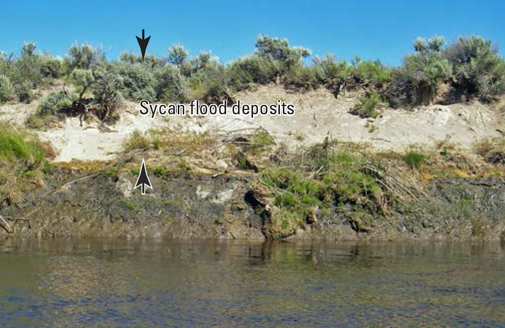
Flood deposits along the Sycan River. (Photograph by Jim O'Connor, USGS) The geologic and geomorphic history creates the physical template for modern fluvial and ecologic processes. For the Sprague River study area, the Neogene and Quaternary history of volcanic activity, basin-and-range faulting, and river integration and incision has established the overall geometry of the basin and produced alternating canyon and wide-valley reaches. Quaternary downcutting and lateral migration has left the suites of terraces and abandoned alluvial fans bounding the active flood plain, particularly in the broad alluvial valleys (plate). Additionally, the flood plain and adjacent landforms have been affected by specific events during the late Holocene, such as the Mazama eruption and the ensuing delivery of substantial sand-size pumiceous sediment to the Sprague and Sycan rivers, as well as more continuous flood-plain and channel processes, such as channel migration and avulsion, and flood-plain accretion and erosion. This section describes mapping (plate) and stratigraphic analyses (appendix A) and the resulting inferences regarding the recent geologic history relevant to the major natural channel and flood-plain processes affecting the Sprague River and lower portions of its major tributaries. Geomorphic UnitsThe area of mapping (plate) consisted of the broad alluvial basins and contiguous fluvial and colluvial landforms flanking the Sprague River and the lower parts of the North Fork Sprague River, South Fork Sprague River, and the Sycan River. Within this area, which closely corresponds to the extent of the LiDAR coverage, 12 fundamental map units were defined (plate; appendix E), reflecting present and past geomorphic environments and events. These landforms, including bedrock (undifferentiated), active and inactive alluvial fans, colluvial slopes, alluvial terraces, spring complexes, tributary and main-channel flood plains, and valley-fill surfaces, are mapped without specific regard to their constituent deposits, which distinguishes this map from typical geological maps. This is especially the case for the terraces and inactive alluvial fans, where alluvial processes have eroded older geologic units, primarily Tertiary lacustrine sediment, leaving landforms with thin and locally discontinuous caps of alluvial gravel. Undifferentiated BedrockIrregular, typically hummocky or steep topography, underlain by Tertiary lacustrine sediment or volcanic rocks was mapped as undifferentiated bedrock. This map unit was defined only where completely surrounded by mapped alluvial or colluvial surfaces. LandslidesArcuate scarps bounding steep, hummocky topography indicate landslide masses. A few landslides are evident in the Chiloquin Canyon segment and in the Coyote Bucket segment of the Sycan River canyon. The Sycan River canyon landslides likely blocked the channel, resulting in the affected stream reaches traversing accumulations of large blocks of volcanic rock down-dropped from the canyon rim. Colluvial SlopesSteep but smooth slopes, up to about 35 degrees, underlain by unconsolidated regolith are formed by gravitational and alluvial transport processes such as rockfall, avalanching, biogenic (caused by living organisms) disturbance, and sheet-wash transport. Colluvial slopes typically head at steep bedrock outcrops, which are the source of material, and transition downslope to alluvial transport surfaces. Colluvium is locally an important source of coarse (gravel-size) material to the Sprague and Sycan rivers, especially in canyon segments, where much of the flood plain is bordered by colluvium or bedrock. The distinction of colluvial slopes and active tributary fans is locally arbitrary, but tributary fans typically have slopes less than 10 degrees. Abandoned Tributary FansIncised, shallowly sloping (less than 10 degrees) alluvial transport surfaces descend toward the Sprague River valley, especially along the southern valley margin between the towns of Sprague River and Bly. Locally, abandoned fan surfaces are enumerated 1 through 4 on plate 1on the basis of increasing degree of incision (and presumably age). The older surfaces have only isolated remnants of original transport surfaces composed of fluvial gravel and are separated from younger (and lower) fan and tributary surfaces by slopes formed in the underlying Tertiary lacustrine sediment. Some abandoned fan surfaces, such as those south of the Sprague River valley near Bly, are formed partly of pumiceous pyroclastic flow deposits derived from Tertiary volcanic centers to the south (Sherrod and Pickthorn, 1992). Near the Sprague and Sycan Rivers, tributary fan deposits are locally interbedded with main-stem fluvial channel and overbank deposits (for example, section 6/28/07-1, shown in figure 4). Primary soil taxonomic classes on abandoned fan surfaces include Haploxerolls, Argixerolls, and Durixerolls, denoting minor to significant accumulations of clays, silica, and carbonate. The ages of these surfaces likely range from Pliocene (but probably post-dating the 3.0±0.9 Ma Basalt of Knot Tableland) to perhaps as young as early Holocene. Where the capping gravel is intact, the abandoned fans are largely stable features that contribute little sediment directly to the modern fluvial system. The sequence of abandoned alluvial fan surfaces indicate overall Tertiary and Quaternary incision of the Sprague River valley, probably in conjunction with integration and incision of the Sprague River through fault-uplifted canyon segments downstream. Active FansShallowly sloping (less than 10 degrees) alluvial transport surfaces grade to modern main-stem and tributary flood plains, commonly with a singular or composite fan-shaped down-gradient termini. These are active alluvial transport surfaces heading from confined tributaries, colluvial slopes and bedrock, and have formed where flow routes expand onto flat terraces, flood plains, and other flat bottomland surfaces. These surfaces are commonly gradational with colluvial slopes and valley bottomlands, but with intermediate slopes. Active fan surfaces are mantled with Haploxerolls, Cryorthents, Cryofluvents, Cryoborolls, and Cryaquepts soil taxonomic classes, all of which have only incipient horizon development in the form of translocated and accumulated carbonates and silica consistent with late Pleistocene to Holocene ages. Many active fans have surfaces post-dating the 7,700 cal yr BP Mazama eruption. Active fans episodically provide sediment to the main-stem rivers and flood plains. TerracesPlanar alluvial surfaces as high as 50 m above the active flood plain flank the Sprague River near its confluence with the Williamson River. Similarly, terraces at several elevations ranging up to 20 m above the active flood plain border the Sprague River downstream of the town of Sprague River (plate). Upstream, isolated low terraces flank the Sprague River near Beatty Gap and along the lower Sycan River. The terrace surfaces are underlain by fluvial gravel, sand, and silt, and are generally stable features upon which Haploxeroll soils have formed, characterized by cambic B horizons and some carbonate accumulation (Soil Survey Staff, 1975). Terrace risers locally expose Tertiary lacustrine sediment or other bedrock units, indicating that at least some of the terraces are strath surfaces cut into the soft Tertiary sediment (figure 4). The positions and degree of soil development are consistent with ages of late Tertiary through Quaternary. All of these terraces apparently pre-date the 7,700 cal yr BP Mazama eruption, judging from the presence of Mazama fallout tephra in the upper parts of their soil profiles (Cahoon, 1985). Like the abandoned alluvial fans, the terraces owe to episodic filling and incision during Quaternary downcutting of the Sprague River. Some of this downcutting may have resulted from base-level fall associated with integration of the upper Klamath River basin (Sherrod and Pickthorn, 1992), but some terrace sequences may reflect more local tectonic blockages associated with the north-northwest trending basin-and-range faulting affecting the downstream Sprague River valley segments or regional aggradation during period of enhanced sediment production in the watershed. Sycan Flood TerraceA prominent planar surface extending south discontinuously from the Sycan River canyon encompasses 5.1 km² of the Sycan River valley bottom and its confluence with the Sprague River. This surface stands 3 m above the active flood plain at the downstream end of Sycan Canyon and descends to modern flood-plain level near the Sycan River confluence with the Sprague River (figures 5 and 6). The surface is underlain by up to 3.35 m of bedded sand and gravel composed almost entirely of Mazama pumice (figure 7). The deposits fine and thin downstream, where they are overlain by alternating beds of silty fine sand and sand. At their apex near the downstream end of the Sycan Canyon, these deposits grade to surfaces mantled with 1-m-diameter rounded basalt boulders, apparently derived from the canyon rim and walls and transported downstream. The soil capping these surfaces is mainly classified as an Ashy Typic Cryopsamment, denoting poorly developed soils formed in sandy parent materials. The pumiceous sand and gravel overlies organic-rich silt and clay deposits, locally peaty, and commonly containing a 0.5-to-2.5-cm-thick layer of silt- and sand-sized Mazama tephra within 3–5 cm from its top,(figures 5, 8, 9, and 10). This fallout tephra (figure 10), its age constrained by radiocarbon dates here (figure 5; appendix B) and in other areas (Hallett and others, 1997; Zdanowicz and others, 1999; Bacon and Lanphere, 2006), resulted from the Mazama eruption of about 7,700 cal yr BP. We infer that the Sycan flood terrace resulted from a large, pumice-laden flood down the Sycan River within a few decades or centuries of the 7,700 cal yr BP eruption. This flood and its genesis and effects are described more fully in Lind (2009). The close proximity of the base of the deposits to unweathered Mazama fallout tephra (figure 10) indicates deposition shortly after the eruption. The lack of stratigraphic breaks or other evidence of deposition hiatus within the thick pumiceous sand indicates deposition during a single event. The sedimentary structures, general upward fining of sediment textures in individual sections as well the downstream fining and flat planar surface also indicate fluvial deposition during a single event. Toward the Sycan River confluence, where the elevation of the flood deposits descends closer to river level, they are overlain by bedded silt and sand deposited by subsequent overbank floods. Although no mappable Sycan flood deposits are evident downstream of the Sycan River confluence, the sediment laden flow almost certainly continued downstream, probably with substantial effects to channel plan form and geometry. A 1948 excavation at Medicine Rock Cave, flanking the Sprague River near FK 11.0 between Braymill and Chiloquin, revealed up to 50 cm of fluvially transported pumiceous sand and silt attributable to a short-lived episode of deposition shortly after the Mazama eruption (Cressman, 1956, p. 398–400). This distinct deposit, interbedded within a sequence of Sprague River fluvial deposits, rock from roof-fall, and occupation detritus, is almost certainly from the Sycan flood, and is evidence that flow was one of the largest late Holocene floods on the main-stem Sprague River to at least near the Williamson River confluence. A plausible source for such a flood was temporary impoundment of a lake in the Sycan Marsh area, possibly by dunes of Mazama pumice blocking the Sycan River channel near the marsh outlet (Lind, 2009). The Sycan flood was probably of similar mechanism, timing, and perhaps magnitude of a flood descending the Williamson River from Klamath Marsh after breach of a Mazama pyroclastic flow deposit that blocked the marsh outlet (Conaway, 2000; Cummings and Conaway, 2009). Sycan flood deposits are coarse, loose, and erode readily from disturbed sites, particularly along tall banks flanking the modern channel or flood plain (figure 7). In eroding areas, the Sycan flood terrace provides substantial sand-sized material to the lower Sycan River. Tributary Flood PlainsTributary channels and flanking surfaces grade to modern main-stem channels and flood plains, forming narrow and elongate surfaces extending into the uplands where channels become increasingly confined. In some areas, especially near Kamkaun Spring, the tributary valleys have very low, nearly horizontal, gradients, whereas in many locations, tributary valley flood plains have gradients approaching 5 degrees. The distinction between tributary fans and colluvium is locally indistinct, but is primarily made on the basis of plan-view morphology and slope. Primary soils on tributary flood plains are Inceptisols and Mollisols, which typically form in late Pleistocene or Holocene deposits (Soil Survey Staff, 1975). Valley FillLow-gradient planar surfaces totaling 28 km2 occupy broad basins flanking the main Sprague River flood plain, particularly downstream of the town of Sprague River. Additionally, this map unit includes narrow bottomlands flanking the post-Mazama zone of channel migration (the geomorphic flood plain as described below) between Sprague River and Beatty Gap. These surfaces generally have soils mapped as Inceptisols or Mollisols formed in part by cumulic deposition of silt and clay during overbank flooding. Many of the surfaces are flooded during periods of high water, but show no evidence of hosting major channels. Many of the surfaces are now diked and drained. Some of the broad valley bottoms marginal to the main river course appear to be sites of long-term sediment accumulation as a consequence of overall Sprague River valley aggradation, perhaps in conjunction with block faulting along the north-northwest trending faults transecting the lower part of the Sprague River valley. In places, this unit may correspond with low terraces mapped upstream of the town of Sprague River. The valley fill map unit everywhere represents areas of Holocene deposition during main-stem overbank flooding as well as from local runoff during seasonal high water. Ponds and WetlandsSeveral small closed depressions host seasonal to perennial waterbodies. In plate 1 these are only distinguished outside of the geomorphic flood plains, although all waterbodies are mapped for each aerial photograph set. Most of these shown on plate 1 are within areas of valley fill or occupy depressions within abandoned alluvial fans. Nearly all are utilized for water storage with dikes or small dams augmenting storage capacity. Spring ComplexesSprings and related features such as ponds, wetlands, and channels are common within the study area. Most are within or contiguous with the geomorphic flood plain or flanking terraces. Spring outlets with flowing water have sandy to gravel substrates, whereas surrounding saturated areas consist mainly of peat deposits. Most spring complexes are connected to the Sprague and Sycan Rivers by sand-bed spring channels. Main-Stem Geomorphic Flood PlainThe channels and active flood plains, encompassing 78 km2 along the North Fork Sprague, South Fork Sprague, main-stem Sprague, and Sycan rivers, are included in a single map unit denoted Main-Stem Geomorphic Flood Plain. This map unit is the domain of the detailed mapping analysis of constructed features, historical channel change, and vegetation described in subsequent sections. This unit encompasses the area of channels, abandoned channels, and bar-and-scroll topography evident on the 2004 LiDAR. The presence of topographic features indicative of channelized flow distinguishes this unit from the Valley Fill unit. Soils are typically poorly drained and volcanic-ash-rich Mollisols dominated by the Klamath-Ontko-Dilman series (Cahoon, 1985). Stratigraphy exposed on eroding streambanks and from augering (figures 5, 8, 9, 11, 12, 13, and 14) show that these flood-plain deposits almost everywhere formed after the 7,700 cal yr BP Mazama eruption. In places, particularly along the lower Sycan River (Lind, 2009) and the North Fork Sprague River, stratigraphic relations show multiple episodes of flood-plain erosion and rebuilding over the last 6,000 years (figures 5, 9, 11, and 14). As described in more detail in subsequent sections, the geomorphic flood plain has formed in the last 7,700 years from a combination of channel migration, channel avulsion, and lateral and vertical accretion of bedload and suspended load deposits. The geomorphic flood plain is mapped on the basis of morphology, soils, and stratigraphy, and does not necessarily correspond to a specific elevation above the channel or areas subject to flooding at a specific frequency. Synopsis of Quaternary Geologic History and Sprague River GeomorphologyThis mapping and previous geologic studies support general inferences regarding the Quaternary geologic history of processes and events that have shaped the Sprague River and its major tributaries. During the Miocene and Pliocene, river networks developing in this area were periodically blocked by lava flows and faulting, creating a landscape of lakes and rivers. The present Sprague River developed after the 3.0±0.9 Ma eruption of the Basalt of Knot Tableland. Since then, widespread lacustrine sedimentation ended and the Sprague River became integrated into the Klamath River drainage. As a consequence of integration, the Sprague River and its major tributaries have generally incised, locally leaving terraces and abandoned and incised alluvial fans (Sherrod and Pickthorn, 1992). This regional incision has probably not been temporally continuous or spatially even, but has been interrupted by changes in sediment influx and transport capacity due to changes in climate, hillslope sediment production, and volcanic sediment influxes; as well as by local uplift and subsidence associated with block faulting along north-northwest to north-northeast trending faults transecting the Sprague River course. Late Quaternary faulting has probably been a major factor affecting the lower 60 km of channel, which winds across the trends of several fault zones mapped by Sherrod and Pickthorn (1992). The prominent steepening of the Sprague River at FK 11.4 may owe to uplift and westward tilting along two up-to-the-west north-trending normal faults at FK 13.0 and 14.5 in conjunction with subsidence to the west of the graben containing Upper Klamath Lake. Tectonic blockage associated with these structures between FK 13.0 and 14.5 is also consistent with the expansive valley fill deposits near Kamkaun Spring and upstream. Although we have no absolute age information on the lowest terraces and abandoned alluvial fans flanking the main-stem rivers, their slightly elevated surfaces up to 2 m above the main-stem geomorphic flood plain, gravel composition and capping soils indicate an episode of late Pleistocene valley aggradation. Such aggradation would be consistent with that found for many western U.S. valleys during and after the last glacial episode 30–20,000 years ago, such as the Willamette Valley of western Oregon (O’Connor and others, 2001). Subsequent to formation of these terrace surfaces, probably during the late Pleistocene, the Sprague River and its major tributaries have incised up to 2 m (figures 4, 8, and 9) in conjunction with forming Holocene flood plains and valley fill. The broad distribution of valley-fill deposits, the locally wide geomorphic flood plain, and the wide tributary flood plains and fans, however, are all geomorphic evidence of little or no net river incision during the Holocene. The position of the 7,700 cal yr BP Mazama tephra in bank exposures and auger holes indicates little widespread incision since the eruption, although local reaches of the lower Sycan River and North Fork Sprague River have had flood-plain erosion and deposition episodes over the last 6,000 years (figures 5, 9, 11, 12, 13, and 14). The 7,700 cal yr BP Mazama eruption profoundly affected the Sprague River fluvial system. Besides multiple indirect effects to basin hydrology and vegetation from as much as 1 m of tephra deposition, the tremendous input of sand-sized tephra to the basin substantially affected flood-plain and channel processes and their morphology. The Sycan River basin, closest to Mt. Mazama and accumulating the thickest tephra fall, was most affected. The Sycan flood, described above, deposited up to 3.3 m of pumiceous sand during a single flood within a few decades or centuries after the eruption, forming a broad fan originally encompassing an area of about 17 km2 with a total sediment volume of 14 million m³ (Lind, 2009). The Sycan River has incised into the Sycan flood terrace (plate 1) and reestablished a flood plain (figures 6 and 14), but the flood terrace remains a source of sand-sized sediment to the Sycan and Sprague Rivers (figure 7). The large volume of sand-size sediment in the Sycan River transformed the river from one with fine-grained cohesive banks and flood plains before the Mazama eruption (figure 5), presumably narrow with slow migration rates, to a more dynamic channel after the eruption, laterally migrating in conjunction with formation of pumice-rich sandy point bars and with episodes of flood-plain erosion and deposition reflecting changes in local and basinwide sediment supply (Lind, 2009). The North Fork and South Fork Sprague Rivers were also affected by the Mazama fallout tephra. Stratigraphic exposures on both forks (figures 8 and 9) show evidence of peaty wetland soils capped by pumice-rich cross-bedded sands, indicating transformation of wet meadows to dynamic sand-bed channels. The stratigraphic exposure along the South Fork Sprague River at FK 98.5 (figure 8) shows subsequent transformation back to a wetland environment before 20th century diking and incision. The exposures along the North Fork Sprague River (figure 9) also show substantial pumiceous sand deposition in point bars followed by transformation to a low-energy wetland environment and production of peaty wetland soils. No exposures along the main-stem Sprague River show the character of the channel and flood plain immediately prior to the Mazama eruption, but flood- plain morphology in conjunction with augering and exposures of late Holocene stratigraphy (figures 8, 12, and 13) indicate episodes of pumiceous-sand point bar formation in conjunction with lateral channel migration and a post-Mazama flood plain much sandier than the muddy overbank deposits exposed on low Pleistocene terrace deposits (figure 4). Active point bar deposits along the main-stem Sprague River remain largely composed of Mazama pumice grains (figure 15). Since the major influx of Mazama tephra following the 7,700 cal yr BP eruption and before historical cultural modifications to the channels and flood plains, the Sprague River and the major tributaries have probably slowly been reverting to pre-eruption sediment transport and flood-plain building conditions, although the tremendous volume of Mazama tephra has left the fluvial system in a substantially coarser state. Evidence from stratigraphic exposures and augering transects indicates that channels and flood plains had stable elevations or were slowly aggrading as a consequence of channel migration, avulsion, flood-plain deposition, and peat accumulation. In conjunction with aggrading main-stem flood plains, active geomorphic surfaces graded to the flood plain, including flanking bottomlands, active tributary fans and flood plains, and colluvial slopes, have probably also widened and aggraded during the last several thousand years. |
Contents:
For more information, contact: Director, Oregon Water Science CenterU.S Geological Survey 2130 SW 5th Ave Portland, OR 97201 Phone: (503) 251-3200 E-mail: info-or@usgs.gov Part or all of this report is presented in Portable Document Format (PDF); the latest version of Adobe Reader or similar software is required to view it. Download the latest version of Adobe Reader, free of charge. |
![]() U.S. Department of the Interior |
U.S. Geological Survey
U.S. Department of the Interior |
U.S. Geological Survey
URL: https://or.water.usgs.gov/proj/Sprague/report/section_5.html
Page Contact Information: Oregon Webteam
Page Last Modified: Wednesday, 19-Jun-2013 18:18:11 EDT
