Oregon Water Science Center
Introduction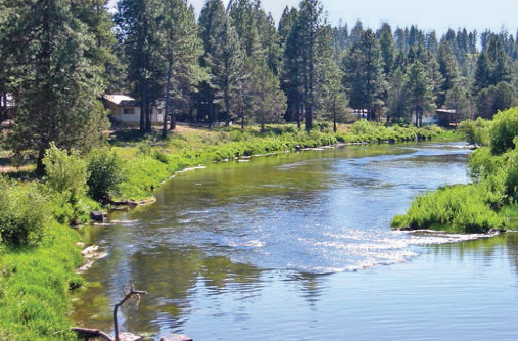
Lower Sprague River near Chiloquin. (Photograph by Jim O'Connor, USGS) The Sprague River basin encompasses 4,167 square kilometers (km2) of south-central Oregon and is a principal tributary (via the Williamson River) of Upper Klamath Lake (fig. 1). The main-stem Sprague River, as well as the lower reaches of the North Fork Sprague River, the South Fork Sprague River, and the Sycan River, meander through broad alluvial valleys historically supporting agriculture and livestock grazing. National and regional interest in restoring Klamath Basin ecosystem conditions and processes has motivated several restoration strategies and projects in the Sprague River basin to improve aquatic, riparian, and upland habitat conditions, particularly for endangered fish species (National Research Council, 2004). The study described herein, jointly conducted by the U.S. Geological Survey (USGS) and University of Oregon and in cooperation with the U.S. Fish and Wildlife Service Klamath Basin Ecosystem Restoration Office and the Hatfield Restoration Program, had the goal of helping management and regulatory agencies evaluate restoration proposals and to guide effective restoration and monitoring strategies for the Sprague River and its principal tributaries by summarizing overall the geomorphic setting and historical and current channel and flood-plain processes and conditions. BackgroundThe Sprague and Sycan Rivers are like many western U.S. rivers for which issues of fish habitat, water quality, climate change, and changing land use have motivated new efforts to manage rivers and flood plains for multiple purposes. These efforts commonly aim to restore river systems where aquatic and riparian habitats have been degraded by historical land use activities, which in the Sprague River basin include timber harvest, agriculture, and livestock grazing. A key issue for the Sprague River basin is that it provides spawning and rearing habitat for two listed (under the Endangered Species Act) fish species, the Lost River and shortnose suckers. Additionally, the 2008 removal of Chiloquin Dam on the Sprague River 1.5 km upstream from the Williamson River confluence, and the possibility of anadramous fish passage being restored for the upper Klamath River basin by changing or removing lower Klamath River dams, increases the importance of the Sprague River and its tributaries for maintaining and protecting valued fish species, possibly including anadromous salmonid species that once ranged into the basin (Hamilton and others, 2005). Water withdrawals, increased stream temperature, high nutrient levels, riparian livestock grazing, and channelization have all likely affected aquatic habitat in the Sprague River (Boyd and others, 2002; National Research Council, 2004). These factors have motivated several restoration activities in the Sprague River watershed, including multiple channel and flood-plain engineering projects, riparian management programs, and upland and flood-plain vegetation treatment programs (Natural Resources Conservation Service, 2009). Such projects, however, are most likely to be successful if designed, implemented, and monitored with an understanding of the geomorphic context and recent history of the local landscape (Thorne and others, 1997; Kondolf and Piegay, 2003). Purpose and ScopeThe objective of this study of the Sprague River basin was to provide an understanding of recent changes to the fluvial systems of the basin, including important physical processes, river and flood-plain geomorphic conditions, and flood-plain and near-channel vegetation. The primary focus of this analysis was the 136.1 kilometers (km) of the main-stem Sprague River, the lower 15.6 km of the North Fork Sprague River, the lower 14.8 km of the South Fork Sprague River, and the lower 30.1 km of the Sycan River. Collectively, this part of the river network encompasses most of the low gradient reaches historically subject to agriculture and livestock grazing, as well as more recent channel restoration activities. Analyses and findings were supported by (1) mapping and measurement of channel and flood-plain features, including vegetation, from historical maps and aerial photographs, and from high resolution Light Detection and Ranging (LiDAR) topographic data acquired in 2004, (2) stratigraphic measurements and analyses of flood-plain deposits, (3) surveys of the effects of 2006 high flows, and (4) geomorphic mapping based on soils, sedimentology, and topography. This report summarizes all aspects of the study. Following short sections on background hydrology, physiography, and history of the Sprague River basin, we briefly describe the overall methods and data sources underlying analyses. A section describing geomorphic surfaces and geologic history provides the basic physical framework of the study area, which is further elaborated in descriptions of the 13 individual valley segments that compose the study area. This is followed by the major substantive sections of the report: descriptions and analysis of physical flood-plain conditions and processes, and flood-plain and near-channel vegetation. For each of these substantive sections, the general progression is a description of the analyses (including methods) and observations, followed by more interpretative discussions of processes and conditions. Key findings are summarized at the end of both of these sections, which support a final section on implications for restoration and monitoring. Units of Measurement and Key LocationsAnalyses and results are presented in metric units. Conversions to English units are provided in the conversion table. Locations along the main-stem and South Fork Sprague River channel are referenced to river kilometers (RK) measured from the Sprague River mouth along the channel centerline mapped from 2000 aerial photographs. Similarly, locations for the Sycan (SYRK) and North Fork Sprague River (NFRK) are measured from their confluences with the Sprague River along the 2000 channel centerline. To avoid ambiguity owing to channel shifting, especially for the historical analyses, most locations are referenced to flood-plain kilometers (FK, SYFK, NFFK) from centerlines bisecting the late Holocene flood plains for the Sprague River and its major tributaries (fig. 1). In 2000, the channel of the main-stem Sprague River and its upstream continuation as the South Fork Sprague River had a total length of 150.9 km within a flood plain 106.2 km long. Similarly, the Sycan River within its lower alluvial reach flows for 16.1 km along a 11.3 km of flood plain, and the North Fork Sprague River meanders for 15.6 km through a 9.8-km-long flood plain. Prominent landmarks and key locations along the Sprague and South Fork Sprague Rivers (table 1) include the former location of Chiloquin Dam (RK 1.3, FK 1.3), USGS streamflow-gaging station 11501000 (RK 8.8, FK 8.3), Braymill (RK 13.3, FK 12.6), Kamkaun Spring (RK 37.0, FK 30.2), the town of Sprague River (RK 79.9, FK 58.1), Council Butte (RK 93.2, FK 66.4), Sycan River confluence (RK 111.8, FK 76.8), Beatty (RK 113.6, FK 78.2), Oregon Water Resources Department (OWRD) streamflow-gaging station 11497500 at Beatty Gap (RK 119.5, FK 81.4), North Fork Sprague River confluence (RK 135.8, FK 93.2), and Bly (RK 137.3, FK 94.3), and just outside the study area is the Sprague River Picnic Area on Highway 140 (RK ~152.3, FK ~107.6). On the Sycan River, the Drews Road bridge and OWRD streamflow-gaging station 11499100 are at SYRK 5.2 (SYFK 2.2), just downstream of the Snake Creek confluence (SYRK 5.4 SYFK 2.4). The Fivemile Creek confluence with the North Fork Sprague River is at NFRK 4.3 (NFFK 1.7). AcknowledgmentsSue Mattenberger of the U.S. Fish and Wildlife Service and Larry Dunsmoor of the Klamath Tribes facilitated this project. Graham Mathews and Associates shared information on their ongoing channel geomorphology and sediment transport analyses and assisted in acquisition of the 1940 aerial photographs. Terry and Jessi Shields (and their family) provided significant logistical support for our field work. Access to field sites was graciously provided by numerous property owners, including Scott Phillips, Rod Kornnelson, John and Lil Kronenberger, Dean and Chloe Walker, Becky and Taylor Hyde, Ken and Dianne Busher, Jim Hadyn-Meyer, Jim Flinn, Greg Bulkley, Bob and Roberta Valladao, Ken Willard, Andrea, Clifford and Mary Rabe, John and Barbara Fugatt, Mike Lelmorini, Dan and Kathy Ridgeway, Greg Harris, and Jim Wayne. We benefited from discussions and assistance from Greg Harris, Michael Hughes, Faith Fitzpatrick, Paul Pedone, Marshall Gannett, Alex Bourdeau, and Dave Sherrod. Analysis and report preparation assistance was provided by Keith Jackson, Tana Haluska, Joseph Mangano, and John Williams. Chris Carlson, Matt Derrick, Benn Hackett, John Lind, Jessica Phelps, and Jason Stuckey assisted in the field. |
Contents:
For more information, contact: Director, Oregon Water Science CenterU.S Geological Survey 2130 SW 5th Ave Portland, OR 97201 Phone: (503) 251-3200 E-mail: info-or@usgs.gov Part or all of this report is presented in Portable Document Format (PDF); the latest version of Adobe Reader or similar software is required to view it. Download the latest version of Adobe Reader, free of charge. |
![]() U.S. Department of the Interior |
U.S. Geological Survey
U.S. Department of the Interior |
U.S. Geological Survey
URL: https://or.water.usgs.gov/proj/Sprague/report/section_2.html
Page Contact Information: Oregon Webteam
Page Last Modified: Monday, 10-Jun-2013 20:28:47 EDT
