Mosier Valley Ground-Water Sustainability Study |
|
In Cooperation with the Wasco County Soil and Water Conservation District
|
| Skip site navigation bar and go to main content Skip main content and go to external links |
GROUND-WATER USE DATA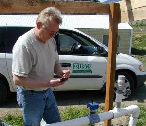 Irrigation pumping is being monitored at 20 wells in the valley during the 2006 irrigation season. Twelve of the wells have been instrumented with special flow meters capable of recording pumping rates every 4 minutes. The detailed pumping data can show the variation in pumping rate for a well depending on the location and number of sprinklers being operated. Two additional wells have standard owner-installed meters that are read manually every month. Power meter readings will be used at the remaining six wells to estimate pumping. Irrigation pumping is being monitored at 20 wells in the valley during the 2006 irrigation season. Twelve of the wells have been instrumented with special flow meters capable of recording pumping rates every 4 minutes. The detailed pumping data can show the variation in pumping rate for a well depending on the location and number of sprinklers being operated. Two additional wells have standard owner-installed meters that are read manually every month. Power meter readings will be used at the remaining six wells to estimate pumping. This graph shows the mean daily pumping rate and cumulative volume pumped for the 14 wells equipped with meters. Daily rainfall is also shown on the lower graph. Pumping data are collected near the 15th of each month and the graph is updated within a few days. Pumping for other uses, such as municipal and domestic supply, will also be estimated for the study and used to compute the overall water budget for the basin. Thanks to all the well owners who have assisted us with the 2006 irrigation water use study! |
|
|
|
| Oregon Water Science Center Studies Page Oregon Water Science Center Home Page |
|
![]() U.S. Department of the Interior |
U.S. Geological Survey
U.S. Department of the Interior |
U.S. Geological Survey
URL: https://or.water.usgs.gov/proj/mosier/wudata.html
Page Contact Information: Oregon Webteam
Page Last Modified: Tuesday, 20-Dec-2016 17:24:55 EST
