Oregon Water Science Center
Flood-Plain and Riparian Vegetation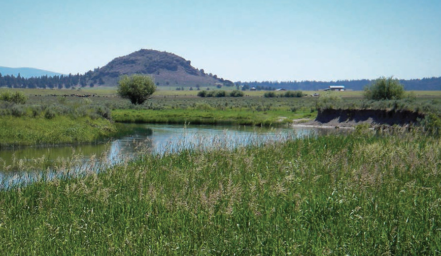
Sprague River near the Buttes of the Gods. (Photograph by Jim O'Connor, USGS) Vegetation interacts strongly with channels and flood plains. Patterns of vegetation within watersheds are controlled by geomorphic character and prevailing land uses, commonly varying locally and through time. In turn, vegetation can affect processes and rates of fluvial erosion and deposition. Flood-plain vegetation in western, semi-arid basins such as the Sprague River's is largely determined by interactions among disturbances (such as flooding), substrate conditions, and moisture availability (Bornette and Amoros, 1996; Hupp and Osterkamp, 1996; Bendix, 1997; Castelli and others, 2000; Amlin and Rood, 2002; Chapin and others, 2002; Li and others, 2006; Bornette and others, 2008). Processes controlling flood-plain vegetation differ spatially relative to the channel. Near-channel environments are more frequently affected by flooding, scour, and burial (Hupp and Osterkamp, 1996; Cordes and others, 1997), but also have more opportunities for establishment of typical riparian species (Karrenberg and others, 2002; Gurnell and others, 2008). Distal flood-plain surfaces are less frequently disturbed by fluvial processes such as overbank flooding, sedimentation, and channel avulsion. These natural processes involving vegetation can be substantially altered by land use. In the Sprague River basin, such alterations include drainage, diking, and cultivation of expansive flood-plain areas, livestock grazing, local timber harvest in some valley segments, and the extensive willow and riparian shrub removal as part of mid-20th century channelization and flood mitigation efforts. This section documents the spatial and temporal variations in the type and extent of vegetation cover within the Sprague River study area. Our analysis parallels that for physical channel and flood-plain conditions by relying on historical observations and systematic mapping from the 1940, 1968, and 2000 aerial photographs. These observations and analyses are combined with available general understanding of riparian vegetation processes to infer mechanisms for evident trends and transitions in vegetation conditions since the first historical observations. Specifically evaluated are (1) the relations among general vegetation patterns and flood-plain geomorphology, (2) temporal variations in these patterns, and (3) the relation of these temporal and spatial changes to geomorphic processes and land use history. The analysis is broadscale with limited evaluation of individual species. More information on the factors controlling distribution of vegetation types in the Sprague River basin is provided by Rasmussen (2011). Overview of Current Flood-Plain VegetationVegetation conditions generally are controlled by the characteristics of the valley segments (table 2), indicating the important influence of channel gradient, sediment supply, flood-plain width, and major tributaries. In general, narrow valleys have higher energy streamflow and coarser channel and flood-plain sediments than wide valley flood plains. Narrow valleys also have higher banks and more topographic shading. Wide valleys have space for development of channel meanders and more flood-plain wetlands. Spring complexes in the flood plain and adjacent surfaces are flanked by riparian and wetland vegetation. Additionally, distinct differences in typical land use among the segments lead to important differences in resulting vegetation conditions. The very narrow Chiloquin Canyon, Braymill, and Coyote Bucket valley segments are largely vegetated with woody species, including willow (Salix sp.) and ponderosa pine (Pinus ponderosa). Small patches of quaking aspen (Populus tremuloides) are locally present, and, in the Chiloquin and Braymill segments, a few individual cottonwood (Populus sp.). The slightly wider S’Ocholis Canyon and Beatty Gap valley segments contain a mix of shrub, herbaceous species, and some tree cover, with small patches of aspen in both segments. Vegetation in wide flood-plain segments is mostly herbaceous; but willows locally flank present and former channel edges. In general, taller banks in confined segments commonly support robust shrub communities, whereas low stream banks, common in unconfined valley segments typically do not, primarily due to saturated soils (Rasmussen, 2011). Although the geomorphic flood plain of the Lower Sycan valley segment is relatively narrow, it is flanked by the broad, dry, and rarely inundated Sycan flood terrace that is vegetated by upland grasses and shrubs. The invasive species reed canarygrass (Phalaris arundicea), is present throughout the study area in near-channel areas of both wide and narrow valley segments, but is particularly well established in the Chiloquin Canyon and Braymill segments. Historical Flood-Plain Vegetation ConditionsUnderstanding historical vegetation conditions provides a basis for evaluating the relation of flood-plain vegetation to channel and flood-plain processes as well as a means for evaluating more recent trends that may owe to land-use conditions and changing process regimes. The main sources documenting early vegetation conditions in the study area are the maps and records of the GLO surveys and records of botanists travelling through the region. Vegetation Conditions Inferred from GLO Surveys and NotesAs with channel conditions, the GLO surveys can provide some quantitative information on vegetation conditions. These surveys, conducted between 1866 and 1892 (table 4), include (1) plat maps that in places show generalized cover with notations such as “forest,” “bottomland,” and “marshes;” (2) section line notes describing landscape conditions along surveyed section lines; and (3) “witness tree” descriptions documenting trees near surveyed section corners. Observations recorded on the plat maps (table 9) indicate that the wide valley segments had sparse tree cover. By contrast, the narrow Chiloquin Canyon and Braymill valley segments were described as forested, and the S’Ocholis Canyon and Beatty Gap valley segments were a mix of herbaceous and timber. The GLO section-line notes documented general conditions along surveyed lines. Surveyors often noted transitions between forest and prairie with statements such as “leaving river bottom” or “entering timber.” Surveys tended to focus on timber and prairie resources, likely for the promotion of agriculture and timber harvest. No direct mention of riparian shrubs is made on any section line survey, except for the Beatty Gap and Upper Valley segments, where large willows served as witness trees (table 9). No aspen stands were mentioned in Beatty Gap, S’Ocholis Canyon, or other narrow valley segments, although some aspen patches exist currently and were present in the 1940s. Section corners and the midpoints of section lines were marked with charred posts, pits, or rock piles. The locations of markers were related to as many as three nearby “witness trees.” The surveyor recorded the species and diameter of each witness tree, and its direction and distance from the marker. An absence of witness trees indicates a lack of nearby trees, thereby indicating non-forest cover (table 9). Smaller shrubs or willows were likely present, but are not mentioned. Pine trees were recorded on flood-plain surfaces only in Kamkaun Spring, S’Ocholis Canyon, and the Lower Sycan segments. Notes mention a single aspen witness tree in the Braymill segment. These conditions are consistent with the very general land classification of Leiberg (1900) encompassing most of the study area west of FK 91.8. The broad vegetation characteristics noted during the GLO surveys currently persist: few trees in the unconfined valley segments, but more forested conditions, including pine and willow, in the narrower valley segments. The wide valley segments were most commonly described as “prairie” although swampy soils and wetland vegetation were noted for the South Fork valley segment. Historical Notes from Botanist William E. LawrenceHistorical observations from the late 1800s (Gatschet, 1890; Leiberg, 1900) are consistent with the inferences of general vegetation conditions drawn from the GLO surveys. Slightly later but more specific information derives from when Oregon State University (then College) botanist William E. Lawrence travelled from Klamath Falls to Lakeview in 1922 and 1934, both times describing vegetation in his field notebooks (W.E. Lawrence Field Journals, Oregon State University Herbarium, Corvallis, Oregon). In each instance his route provided views of the Beatty–Sycan, Beatty Gap, and South Fork Sprague valley segments as he closely followed the present route of Oregon State Highway 140 eastward. Some informative observations by Lawrence include: July 1, 1922“No trees are to be found in the Beattie flat. The kind of sage was not noted” “In brief it was Populus, etc. and Ribes aureum along the river. Kunzia tridentate [bitterbrush] then Artemesia tridentat[a] [sagebrush] and a little Ribes cereum [wax currant] with yellow pine [ponderosa pine] farther up.” July 3, 1922“The currants grow in quantity along the creek bottoms. This is Ribes aureum. It is along the Sprague River in quantity. It extends from above Bly at Sec. 10T 37R 16 [upstream of the study area] down the river in abundance for 8 miles. It grows here in thick bodies. Below here it extends scattering with the willows down into the Reservation.” July 30, 1934“Sprague River junction [near Beatty]. There is an extensive natural meadow flat here which extends along the river bordered with Salix.” “Bly…..has certainly grown since 1922 when last I passed through. The saw mill has evidently brought about the change.” From these observations, at the time of Lawrence’s trips, much of the river corridor upstream of Beatty had a distinct riparian vegetation community, with locally thick growths of shrubby species, including willow, interspersed with grass meadows. Higher surfaces were vegetated with typical semi-arid shrubby species such as sagebrush and bitterbrush. But, consistent with the diking and diversions already in place, “productive areas” were cultivated for hay. Aerial Photograph AnalysisMore quantitative assessment of vegetation conditions result from analyses of the vertical aerial photographs dating from 1940, 1968, and 2000 (table 4). Analysis was based on vegetation mapping in conjunction with the mapping of channel and cultural features (table 5). This mapping allows analysis of conditions in 2000 as well as changes and transitions since 1940. The analyses were conducted at two spatial scales: (1) broadly of the entire flood plain and (2) more focused analysis of conditions within a 40-m-wide swath centered about the primary channel centerline, which we term the near-channel area. Vegetation Mapping and AnalysisThe mapped vegetation classes are bare, herbaceous, short woody, and tall woody (table 10). These classes approximately match National Wetland Inventory (NWI) protocols which divide Forested and Scrub-Shrub wetland types at the 6-m threshold (Cowardin and others, 1979). As in the NWI method, young trees less than 6-m-high are classified as short woody. Mapping on this basis was performed for the entire geomorphic flood plain for each of the three aerial photograph sets. As for the channel and flood-plain geomorphic characteristics, the different aerial photograph sets introduced some challenges to consistent vegetation mapping. The 1940s set was taken at different times over the summers of multiple years and covered a smaller area than in 1968 and 2000 (table 4). All photo sets used were black and white, although a high resolution, true-color set from 2005 enabled checking type and position of vegetation stands. Vegetation types were also field checked to verify characteristics. The North Fork and South Fork valley segments had little coverage in the 1940s photographic set, consequently results from these valley segments are only used for some analysis components. Because of limited aerial photograph coverage, the Coyote Bucket segment of the Sycan River was not included in any vegetation analyses. Mapping consisted of delineating patches of vegetation classes (except for herbaceous), typically at scales ranging between 1:1,000 and 1:2,000. The minimum patch size was 20 m², or for the short woody and tall woody classes, areas that included five or more individual trees separated by less than 20 m. Individual trees were not mapped. Tall and short woody vegetation was mapped primarily on the basis of structure rather than tree species; however, many tall woody species were recognizable from the imagery. In particular, pines were very dark on the photos, sometimes nearly indistinguishable from the accompanying shadows. Quaking aspen had round crowns for individual trees; larger stands had a mottled texture, and tone was typically darker than the shorter and patchier willow and lighter than adjacent pine. Portions of the 1968 photo set were taken prior to leaf-out for the aspen trees, making crown identification locally difficult, although crown shadows were distinctive, even without leaves, making mapping possible in most cases. Short woody vegetation was primarily young trees of the tall woody species as well as willow and other shrubs typically found along channels.Once all woody vegetation was mapped, areas without any vegetation were delineated and classified as bare. Houses, roads, and bridges were classified as bare. Consistent with field conditions, all surfaces not mapped as water (from the physical flood-plain mapping), tall woody, short woody, or bare were assumed to be covered with herbaceous vegetation. Once completed, all areas within the geomorphic flood-plain boundary were assigned one (and only one) of five cover-type classifications: water, bare, herbaceous, short woody, or tall woody. Spatial Distribution of Vegetation in Year 2000The vegetation patterns mapped from the year 2000 aerial photographs (table 11, figure 61) allows examination of the relation between recent vegetation patterns and flood-plain width, and the differences in vegetation patterns between flood-plain and near-channel zones. Other potential controlling factors such as stream or valley gradient, soil type, or flood-plain elevation, were not evaluated. Water (including all channels and backwater areas) covers a much greater percentage of the narrow flood plains than the wide flood plains; accounting for as much as 40 percent for the confined valley segments but less than 10 percent for most of the unconfined valley segments (table 11). The confined valley segments have a much higher proportion of woody vegetation than the unconfined valley segments (table 11). Chiloquin Canyon, Braymill, S’Ocholis Canyon, and Beatty Gap all have more than 25 percent of their flood-plain areas covered by woody vegetation, compared to less than 10 percent for the unconfined valley segments. The Council Butte valley segment has woody vegetation covering less than 0.1 percent of the flood-plain area. The Lower Sycan valley segment, while narrow with a mean flood-plain width of 220 m, has only 7 percent woody cover compared to the 32 percent woody cover for the slightly narrower Beatty Gap. Some of this difference owes to the greater solar exposure (and probably drier conditions) of the Lower Sycan valley segment, which is oriented north-south and flanked by low terraces composed of coarse sandy soils, whereas the other narrow segments are within more shaded canyons entrenched into volcanic rock. Part of the difference probably also owes to the substantial decline of woody cover in the Lower Sycan valley segment, which had 23 percent woody cover in the 1940 aerial photographs. For all valley segments, most of the woody cover is short woody vegetation. Tall woody vegetation composes more than 15 percent of the cover only in the narrowly confined Chiloquin Canyon and Braymill valley segments. In all other segments, short woody vegetation cover exceeds tall woody vegetation by a factor of two or more (table 11, figure 61 ). The Buttes of the God, Beatty–Sycan, and Upper Valley segments had no mappable tall woody vegetation in 2000. Herbaceous cover dominates the flood plains of the wide and unconfined valley segments, which all have more than 75 percent herbaceous cover (over 90 percent in the Upper Valley and South Fork segments). Herbaceous vegetation covers more than 50 percent of the flood plain for all valley segments in the study area except for the confined Chiloquin Canyon and Braymill valley segments. Near-channel areas within 20 m of the channel centerline had vegetation patterns in 2000 similar to the corresponding flood-plain patterns but with some consistent differences (table 12; figure 62). These differences include (1) bare ground is a larger component of surface cover in the near-channel zone than on the flood plain, reflecting the presence of active bar surfaces and bare banks along the channel, (2) tall woody vegetation is less prevalent in the near-channel zone than on general flood-plain surfaces, likely due to intolerance of aspen and ponderosa pine to the greater frequency and extent of soil saturation near the channel, and (3) short woody vegetation occupies a slightly greater percentage of the near-channel zone than of the whole flood plain in most valley segments. The slightly greater abundance of short woody shrubs (typically willow) in the near-channel area may reflect higher availability of seeds and germination sites, as is the case for riparian areas in many semi-arid regions (Karrenberg and others, 2002). The difference in extent of short woody cover between the near-channel and flood-plain areas is most pronounced in the narrow confined valley segments, which may reflect the higher flood plains (figure 17) or lower migration rates (figure 44) in these reaches. Vegetation Trends, 1940–2000Trends in vegetation patterns are evident from the vegetation mapping based on the 1940, 1968, and 2000 aerial photographs (tables 11 and 12, figures 61 and 62). For the geomorphic flood plain, study-area totals from 1940 to 2000 (excluding the North Fork, South Fork, and Coyote Bucket valley segments for which the aerial photographs are incomplete) show a gain of herbaceous cover (increasing from 78.2 to 81.5 percent of the analysis area) and loss of short woody cover (decreasing from 7.7 to 4.8 percent of the study area; table 11). Other changes were less than 1 percent, including slight gains in tall woody vegetation and bare areas and a loss of water-covered area. While being a relatively small decline with respect to the total flood-plain area, the decline of short woody vegetation between 1940 and 2000 represents a loss of 38 percent of its 1940 area and is by far the largest relative change in any of the mapped cover types. Most of the change in total flood-plain cover of short woody vegetation was during the 1940–1968 period, when 138 ha were lost along the main-stem Sprague River and Lower Sycan valley segment (table 11). Subsequently, between 1968 and 2000, short woody vegetation cover decreased by an additional 6.6 ha. By contrast, herbaceous cover gained more area between 1968 and 2000, when its extent increased by 129 ha compared to increasing by only 36.6 ha during 1940–1968. Tall woody vegetation cover increased by small areas during each analysis period. Both the area covered by water and bare ground increased between 1940 and 1968 and then decreased between 1968 and 2000. The total net loss of water-covered area between 1940 and 2000 was 48 ha. Most large changes in cover type were widespread (table 11, figure 61). In particular, declines in short woody cover were measured for all valley segments between 1940 and 1968. Likewise, all valley segments except Chiloquin Canyon gained herbaceous cover during 1968–2000. Partly in conjunction with the gain in herbaceous cover, nearly all valley segments lost water and bare areas during the 1968–2000 period. As a percentage of flood-plain area, the more confined valley segments of Chiloquin Canyon, Braymill, S’Ocholis Canyon, and Beatty Gap had similarly large losses of short woody cover, with each of these valley segments having reductions of between 5 and 6 percent of short woody cover between 1940 and 1968. These declines, however, were matched or exceeded by the 6 percent decline of short woody vegetation in the Upper Valley segment and the 12 percent decline in the Lower Sycan valley segment between 1940 and 1968. Both of these valley segments had substantial expansions of herbaceous cover during this same time period. In general, changes as a percentage of flood-plain area were smaller during the 1968–2000 period, with only 2 valley segments showing any cover-type change greater than 5 percent during the more recent analysis period compared to 6 of the 10 segments having such changes during the 1940–1968 period. The temporal trends in the near-channel area for the main-stem Sprague River (excluding the North and South Forks) and Lower Sycan were similar as for the entire flood plain, but with greater fluctuations in water, bare, and short woody cover types (table 12, figure 62). The difference in water and bare cover types in part reflects the higher water levels during acquisition of the 1968 aerial photographs and the bar growth during the 26 December 1964 flooding. The loss of short woody vegetation, however, matches the long-term trend for the entire flood plain, although the relative magnitude is even greater for the near-channel area, where the total area decreased by nearly 50 percent, from 154 ha (14 percent of the near-channel area) in 1940 to 87 ha (8 percent of the near-channel area) in 2000. Most of this decrease was during the 1940–1968 period, when 67 ha were lost. Documented loss of short woody vegetation would have been larger if the North Fork and South Fork valley segments were included in these tabulations; despite the incomplete aerial photographic coverage for 1940, systematic declines in short woody vegetation cover are evident for those segments as well. While all valley segments had net loss of short woody cover in near-channel areas between 1940 and 2000, the greatest relative losses (exceeding 50 percent of the 1940 area) were in the Kamkaun Spring, Buttes of the Gods, Council Butte, Beatty–Sycan, Upper Valley, North Fork, and Lower Sycan valley segments (table 12, figure 62. The South Fork valley segment likely had a similar reduction. Beatty Gap had a smaller relative loss of short woody vegetation, but also had a nearly 50 percent loss in tall woody vegetation in the near-channel area between 1940 and 2000. Vegetation TransitionsTemporal and spatial trends can hint at controlling processes, but more specific inferences can be developed from information on the site-specific changes of cover types. A transition matrix analysis identifies all of the possible changes in land cover classes, allowing determination of transitions that are most prevalent during different time periods. Transitions can be related to successional processes as well as human and natural disturbances. Transition matrix analysis has been used in landscape scale investigations of land use (Petit and others, 2001), grassland and woodland interactions (Hibbard and others, 2003), and dune and delta environments (Shanmugam and Barnsley 2002; Biondini and Kandus 2006). This analysis evaluated the change in mapped cover type for each square meter of flood plain between 1940 and 1968 (appendix H, table H1) and between 1968 and 2000 (appendix H, table H2). For each analysis period, cover changes were recorded as 1 of 21 transitions, accounting for the 20 possible transitions of one cover type to another plus that of “No Change.” The transition analysis was conducted separately for the near-channel area comprising the 20 m extending laterally in each direction from the channel centerline (appendix H, tables H3 and H4). For the transition analysis, the near-channel area remained fixed about the 1940 centerline, except for where 1940 aerial photograph coverage is unavailable upstream of FK 95.2 on the South Fork valley segment and upstream of NFFK 5.8 on the North Fork valley segment. For the upstream parts of these valley segments, the transition analysis was restricted to the 1968–2000 period for the near-channel area flanking the 1968 channel centerline. More than 90 percent of the flood-plain surface within the analysis area did not change cover type for both time periods (appendix H, tables H1 and H2). Nevertheless, the confined segments were more dynamic, with the Chiloquin Canyon, Braymill, S’Ocholis Canyon, Beatty Gap, and Lower Sycan valley segments all having about 20 percent or more of their flood plains change cover classes during each of the analysis periods (figure 63). Vegetation classes in the unconfined valley segments remained constant for about 90 percent of the flood-plain areas. The South Fork valley segment was the most static, with 98 percent of its flood plain remaining the same cover type for the 1968–2000 period. The near-channel area was more dynamic than the flood plain as a whole, with 25 percent of the area changing cover class during the 1968–2000 period (27 percent between 1940 and 1968) (appendix H, table H3; figure 63). These high near-channel rates explain the relatively high rates of total flood plain transitions in the confined reaches (figure 63A), where the near-channel areas compose a greater percentage of the flood-plain area. The most dynamic segments in terms of near-channel vegetation transition were the Lower Sycan and North Fork valley segments, where about 40 percent of the near-channel area changed cover classes during both analysis periods. The Upper Valley, Beatty Gap and S’Ocholis Canyon valley segments also had more than 25 percent of the near-channel area change cover types during both analysis periods. The valley segments with the most consistently stable near-channel vegetation cover class were the Buttes of the Gods, Chiloquin Canyon, and Braymill segments, for which less than 20 percent of near-channel area changed during the 1968–2000 analysis period. Examination of the individual transition categories also reveals trends (figures. 64 and 65), clarifying changes evident from the overall change analysis. The greatest changes for both time periods and for both the entire flood-plain and near-channel areas involved cover-type transitions between (1) short woody and herbaceous, (2) water and herbaceous, and (3) water and short woody. In particular, for the 1940–1968 period, nearly every segment showed substantial conversion of short woody to herbaceous and short woody to water. For the 1968–2000 period, these particular transitions were more balanced. Other pronounced transitions include the widespread transition of bare to herbaceous and water to herbaceous in the 1968–2000 period, again reflecting the lower water level depicted in the 2000 aerial photographs and the greater area of bars in the 1968 photographs (figures 64 and 65). Also evident is the widespread conversion of the tall woody cover class to other cover types during the 1968–2000 period. This trend is evident only for the flood plain as a whole and is not mirrored in the near-channel area, indicating that most of these changes were in areas away from the channel. These transitions can be viewed with respect to successional pathways and vegetative structural complexity. In the absence of disturbance, the expected successional progression is bare to herbaceous to short woody to tall woody. This progression also generally results in increasing structural complexity, involving increasing diversity of plant types, plant heights and habitat heterogeneity. Movement in the opposite direction typically requires some sort of disturbance. From this perspective, cover-type transitions to the right of the central vertical lines in figures 64 and 65 indicate advancing seral stage and structural complexity, whereas those to the left indicate declining seral stage and complexity, likely resulting from site disturbances or erosion. Consequently, the aerial photograph analysis generally shows declining seral stage for most possible transitions for the 1940–1968 period for the flood-plain and the near-channel corridor, particularly for areas covered by short woody vegetation in 1940. For the 1968–2000 period, the analysis of the flood plain shows systematic declining seral stage associated with tall woody vegetation, but herbaceous growth in many areas that were either bare or underwater in 1968. Many valley segments also had conversion of herbaceous to short woody vegetation. Findings were generally similar for the 1968–2000 period in the near channel area aside from little evidence for the declining tall woody cover class seen at the flood-plain scale. Summarizing the transitions by advancing and declining seral stage for each valley segment shows that for all valley segments, the relative area of declining seral stage was greater in the 1940–1968 period than in the 1968–2000 period for both the flood-plain and near-channel areas (figure 66). In general, however, 1940–1968 declines were more pronounced in the in the near-channel areas, particularly for the S’Ocholis Canyon, Beatty Gap, Upper Valley, and Lower Sycan valley segments. Beatty Gap and Lower Sycan also had large net declines when considering entire flood-plain area. Many of these segments with substantial 1940–1968 declines, however, had net increases in seral stage for the 1968–2000 period, especially the S’Ocholis Canyon, Beatty Gap and Lower Sycan valley segments. Major Vegetation Changes and Their CausesThese vegetation and cover-type changes, in conjunction with understanding of successional processes, land-use, and channel and flood-plain dynamics, allow inference of the key factors controlling present vegetation patterns and recent trends in the Sprague River study area. Beyond this, Rasmussen (2011) provides more specific information on relations between channel, soil moisture, land-use, and riparian vegetation processes in the Sprague River study area. Transitions among Water, Bare, and HerbaceousVariations and transitions among these cover classes chiefly owe to changes in channel pattern, inundation and disturbance. Historical observations and the aerial photograph analyses show that the flood plains, especially for the unconfined segments, were largely vegetated by herbaceous species (figures 61 and 62). Consequently, transitions involving herbaceous cover tend to occupy larger areas than for other cover types. Transitions between water and herbaceous cover types primarily result from (1) channel movement, either by lateral erosion or avulsion, into flood-plain areas covered by herbaceous vegetation, (2) inundation of areas covered by herbaceous vegetation, (3) excavation of ditches and storage ponds, and (4), in the other direction, emergence or colonization of herbaceous vegetation in areas formerly covered by water. All of these processes were probably important in the analysis area. The total net reduction in water-covered area between 1940 and 2000, mainly resulting from decreased channel sinuosity, accounts for 29 percent of the increase in herbaceous area in the region during this period (appendix H, tables H1 and H2). Also, the lower water levels of the 2000 aerial photographs compared to those of the 1968 photographs is the chief reason for the substantial transition of water cover to herbaceous between 1968 and 2000 (figures 64 and 65), although the 1–6 percent of the near-channel area that went from herbaceous to water during this time likely reflects channel migration. Bare areas indicate recent disturbance. This is most evident in the substantial increase in bare area shown by the 1968 aerial photographs, particularly in the near-channel areas (figures 61 and 62). This is consistent with the increased bar area at this time (figure 38) and almost certainly reflects erosion and deposition during December 1964 flooding, primarily in areas formerly covered by herbaceous vegetation. Some bare areas, however, are created and maintained by livestock trampling, roads, and water access paths (figure 67). The consistent reduction of bare area and conversion of bare to herbaceous in the Chiloquin Canyon valley segment likely reflects decreased land disturbance as a consequence of diminished mill operations. Short Woody VegetationHistorical observations note the presence of willow and currant along the channel throughout the study area, including small amounts in the unconfined valley segments otherwise vegetated mainly by herbaceous cover types. Short woody vegetation has declined substantially since those historical observations, particularly in the Beatty–Sycan, Upper Valley, and South Fork valley segments where William E. Lawrence recorded conditions in the early 1900s. This trend has continued for several valley segments over the 1940–2000 aerial-photograph analysis period. As noted above, during this time, the area of short woody vegetation declined by 38 percent in the flood plain and by 50 percent in the near-channel area (appendix H, tables H1, H2, H3, and H4). Most of these losses were in the 1940–1968 period and involved transitions to herbaceous, water, and bare cover types (figures 64 and 65). Short woody cover in the 1940s (table 11) tended to occur in large patches, with no apparent preference for near-channel zones. Patches were considerably smaller and much more fragmented in 1968, with many patches disappearing before the 2000 photos. For the Lower Sycan valley segment, these three transitions encompassed 20 percent of the near-channel area. The transitions all represent declines in seral stage, indicating that disturbance processes were primarily responsible. Subsequent to 1968, the area covered by short woody cover continued to decline but by a much smaller fraction, and multiple valley segments gained more short woody cover from succession from water, bare, and herbaceous cover types than was lost by disturbance. Multiple factors probably account for the decline of short woody vegetation. Areas of transition from short woody cover to water and bare probably in part reflect fluvial erosion of riparian shrubs from channel margins. But as described for other montane environments (Shultz and Leininger, 1990; Green and Kauffman, 1995; Holland and others, 2005), livestock trampling and grazing are also likely factors in reducing the area of short woody vegetation, especially in the multiple areas where losses resulted from shrinking and fragmentation of short woody vegetation patches (instead of complete removal, which would be the consequence of mechanical conversion to pasture). This transition from short woody cover to bare accounts for 21–40 percent of the near-channel areas losing short woody cover between 1940 and 1968, with the largest values being in the confined Chiloquin Canyon, Braymill, and S’Ocholis Canyon valley segments. Some unknown portion of this change owes to the higher water levels of 1968, but the 2–18 percent of the near-channel areas that transitioned from short woody cover to bare between 1940 and 1968 almost certainly resulted from fluvial erosion, except for isolated locations of human disturbance. The transition from short woody to herbaceous was the most frequent transition associated with loss of short woody cover for all valley segments for both the 1940–1968 and 1968–2000 time periods, and for both the near-channel area and entire flood plain. For near-channel areas, this transition accounted for 40–70 percent of the loss in each valley segment for 1940–1968 and 64–91 percent for 1968–2000. This transition was even a larger factor for the entire flood plain, accounting more than 90 percent of the short woody vegetation loss for several of the wider and unconfined valley segments. In near-channel areas, this transition can also be due to fluvial erosion and subsequent colonization of bare surfaces by herbaceous vegetation. But the widespread transition of short woody cover to herbaceous in flood-plain areas away from the near-channel zone indicates that fluvial erosion was likely not a major factor and that conversion to pasture and agriculture contributed to the loss of short woody vegetation. Additionally, livestock grazing and mechanical removal (as was the case for willow removal along the Sprague River during the 1950s and 1960s) can convert short woody cover to herbaceous (Schultz and Leininger 1990; Green and Kauffman 1995; Holland and others, 2005). Both of these activities have probably been significant contributors in the loss of short woody vegetation in the Sprague River basin, particularly between 1940 and 1968. Other factors possibly contributing to the decline of short woody cover are disease, insects, and predation by wildlife. After sustained high water in the spring of 2006, willow stands across much of the basin were infected with a rust fungus during the following growing season. Leaves yellowed and fell mid-season, though re-foliated normally the following spring. Predation by beaver and muskrat is prevalent throughout the study area, although greatest in patches in the near-channel zone. Isolated shrubs and small willow patches in the wide flood-plain segments can be decimated by beaver predation where activity is concentrated. Over time, these local pressures on shrub growth may become evident at the level mapped in this study, although their present effects are unknown. Tall Woody VegetationTall woody vegetation is typically sparser than all other cover types in the study area, and was not present in 2000 for the Buttes of the Gods, Beatty Sycan, and Upper Valley segments (table 11; figure 61). But in the Chiloquin Canyon, Braymill, and S’Ocholis Canyon segments, tall woody cover has increased by 32–66 percent between 1940 and 2000. Most of the increase has been from water, herbaceous and short woody cover types, indicating general succession in these historically timbered flood-plain sections. In the Beatty Gap valley segment, however, tall woody cover has declined from 9.8 ha to 6.1 ha between 1940 and 2000 (appendix H, tables H1 and H2; figure 61). About 40 percent of the loss was from the near-channel area (figure 62). A small portion of the decline in tall woody cover resulted from tall woody cover areas transitioning to water (particularly between 1940 and 1968), probably from fluvial erosion of timbered stands (figure 28). But 75 percent of the net decline of tall woody vegetation resulted from transition to short woody cover types, particularly in the near-channel area between 1940 and 1968 and for the broader flood plain between 1968 and 2000. This transition is possibly due to dieback of aspen patches. Losses from the near channel area may have been enhanced by beaver activity, judging from recent beaver fall observed during field inspections. Summary of Flood-Plain and Near-Channel Vegetation ConditionsGeneral spatial patterns of vegetation in the Sprague flood plain in 2000 were influenced by broadscale basin characteristics and had remained generally similar since government surveys in the 1800s. Tall woody species prefer narrow, confined, and shaded flood plains; wide flood plains are mostly covered with herbaceous plants, but past and present channel areas are locally flanked by short woody vegetation. These predominant attributes have remained constant since the first historical observations, chiefly because the areas within the study area have remained generally pastoral without substantial urbanization, timber harvest (within the flood plain) or changes in flow and sediment regimes. At finer scales, however, near-channel areas are more dynamic than the flood plain as a whole, with about 25 percent of the near-channel area changing cover class during each 28–32-yr analysis period compared to only 10 percent for the flood plain. The greater vegetation dynamics of the near-channel area reflect the important roles of fluvial disturbance and succession in creating riparian vegetation communities, and were perhaps exacerbated by predation and concentrated grazing. Despite the general stability of overall vegetation patterns, some clear trends are evident among individual cover types. The most systematic and broadscale change has been the loss of short woody vegetation—only half the near-channel area covered by short woody vegetation in 1940 was similarly covered in 2000. The loss of short woody vegetation to less complex early seral stages was the chief change among many indicating vegetation disturbance and loss of structural complexity. These changes were most substantial prior to 1968. In the 1940–1968 period, the Kamkaun Spring, S’Ocholis Canyon, Beatty Gap, Upper Valley, and Lower Sycan valley segments generally showed the greatest declines in seral stage. The North Fork and South Fork valley segments were also likely similarly affected during this period, but quantitative information is not available prior to 1968. Since 1968, overall vegetation trends are not as evident except for (1) continued loss of short woody cover in all valley segments upstream of the Sycan and Sprague River confluence, (2) loss of bare area in nearly all valley segments, and (3) increase in tall woody vegetation in the Chiloquin Canyon and Braymill valley segments. These changes have resulted from a combination of geomorphic processes and trends, vegetation succession, direct vegetation manipulation, and broad-scale land-use. Transitions among the bare and water cover types are chiefly the result of decreased sinuosity, different water levels at the time of the aerial photographs, and the December 1964 flooding, which created many bare bar areas evident in the 1968 photographs. Vegetation succession has locally increased seral stage and habitat complexity, partly balancing the effects of disturbance processes, particularly since 1968. Woody vegetation removal in the 1950s and 1960s, in conjunction with continuing grazing and trampling by livestock are probably the main reasons for the decline of short woody vegetation from the dense riparian corridors of willows and other riparian shrubs noted in the early 20th century. |
Contents:
For more information, contact: Director, Oregon Water Science CenterU.S Geological Survey 2130 SW 5th Ave Portland, OR 97201 Phone: (503) 251-3200 E-mail: info-or@usgs.gov Part or all of this report is presented in Portable Document Format (PDF); the latest version of Adobe Reader or similar software is required to view it. Download the latest version of Adobe Reader, free of charge. |
![]() U.S. Department of the Interior |
U.S. Geological Survey
U.S. Department of the Interior |
U.S. Geological Survey
URL: https://or.water.usgs.gov/proj/Sprague/report/section_8.html
Page Contact Information: Oregon Webteam
Page Last Modified: Tuesday, 11-Jun-2013 19:50:33 EDT
