Oregon Water Science Center
The Sprague River Basin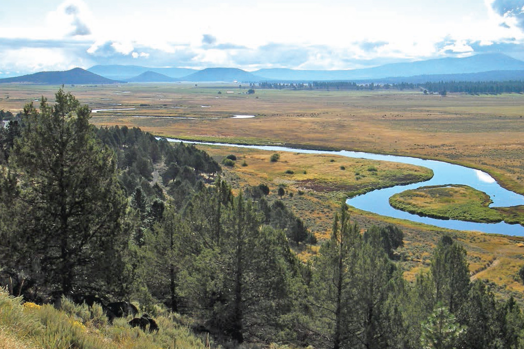
Sprague River Valley near Council Buttes. (Photograph by Jim O'Connor, USGS) The Sprague River (fig. 1 and plate) drains 4,167 km² of south-central Oregon before joining the Williamson River 17 km upstream from the Williamson River confluence with Upper Klamath Lake. The Sprague River contributes about 55 percent of the mean annual flow of the Williamson River at their confluence. The Sprague River begins at FK 93.2 (RK 136.1) with the confluence of the North Fork Sprague River (drainage area 759 km²) and South Fork Sprague River (drainage area 534 km²). From there the Sprague River flows through alternating wide valleys and canyon reaches and joins the Williamson River at the town of Chiloquin. Principal tributaries are the Sycan River at FK 76.8 (drainage area 1,447 km²) and Trout Creek at FK 48.0 (drainage area 71 km²). About half of the watershed, including much of the headwaters and uplands, is within the Winema and Fremont National Forests. About 46 percent of the basin is privately owned, including much of the Sprague River flood plain and the lower reaches of the North Fork Sprague River, South Fork Sprague River, and Sycan River. In 1988, a 95-km reach of the Sycan River was designated as a Wild and Scenic River to a point 20 km upstream of its Sprague River confluence. Also, the Gearhart Mountain Wilderness Area (not shown; east of location map) includes portions of the South Fork (24 km²) and North Fork (44 km²) Sprague River headwaters. The Sprague River watershed is within Klamath and Lake Counties. Principal towns within the basin are Chiloquin, Sprague River, Beatty, and Bly. Geography and GeologyWithin the northernmost extent of the Basin and Range physiographic province (Fenneman, 1931), the Sprague River basin spans multiple uplifted ranges and volcanic centers separated by fault-bounded valleys. The basin margin includes Gearhart Mountain (2,549 m) west of Winter Rim (not shown; east of location map, which separates the Sprague River basin from the closed Summer Lake basin to the northeast, and Yamsey Mountain (2,498 m) to the north, dividing the Sprague River basin from the upper Williamson River. The southern basin margin is formed by lower ranges separating the Sprague River basin from those of the Lost River and Goose Lake (not shown; part of the Sacramento River basin). High points along the southern basin margin include Saddle Mountain (2,085 m), Bly Mountain (1,789 m), Yainax Butte (2,201 m), and Fishhole Mountain (2,154 m). The alluvial bottom lands flanking the Sprague River range from the 1,268-m-elevation confluence with the Williamson River to about 1,350 m in the broad valley upstream of the North and South Fork Sprague River confluence. The mean elevation of the basin is 1,600 m (Risley and others, 2008). The Sprague River basin is underlain by late Tertiary and Quaternary volcanic and sedimentary strata locally offset by north- to northwest-trending normal faults (Sherrod and Pickthorn, 1992; Jenks, 2007). The uplands are chiefly underlain by upper Miocene and Pliocene basalt and basaltic andesite lava flows issued from local vents and shield volcanoes, locally overlying older and more siliceous lava flows and domes. One of the younger basalt flows, the Basalt of Knot Tableland, flowed down the paleo Sycan River valley, partly filling and blocking the Sprague River valley 3.0±0.9 million years ago (Ma; Sherrod and Pickthorn, 1992). Some of the prominent buttes within the Sprague River valley, particularly near the town of Sprague River, are tuff cones formed by volcanic centers venting through lakes and wet lake sediment. The broad alluvial valleys of the Sprague River are chiefly excavated into weakly consolidated Miocene and Pliocene diatomites, mudstones, sandstones, conglomerates, and tuffs deposited in lake basins and broad valleys bounded by block-faulted uplifts or lava flows. Incision of the modern valleys probably commenced with integration of the Sprague River drainage with a Cascade-Range-bisecting Klamath River in the late Pliocene (Sherrod and Pickthorn, 1992). The present river winds westward through the fault bounded uplifts and down-dropped basins, resulting in alternating narrow canyon and wide valley segments, before joining the Williamson River in the younger and more pronounced graben containing Upper Klamath Lake and the lower Williamson River. The Sprague River watershed was profoundly affected by the eruption of Mount Mazama that formed Crater Lake caldera 7,400–7,700 calendar years before present (cal yr BP; Bacon, 1983; Bacon and Lanphere, 1990; Zdanowicz and others, 1999). The climactic eruption ejected 50 cubic kilometers (km3) of dense rock equivalent, forming a widespread fallout tephra covering more than 1,000,000 square kilometers (km2) of western North America (Sarna-Wojcicki and Davis, 1991). Fallout tephra thicknesses exceed 1 meter (m) in the northwestern part of the Sprague River watershed (Sherrod and Pickthorn, 1992) but diminish to less than 1 centimeter (cm) in the southern and eastern parts of the basin. In addition to hydrologic and vegetative effects (Newberry, 1857; Minckley and others, 2007; Cummings and Conaway, 2009), remobilization of the silt-to-granule-size pumice changed the character of the Sprague and Sycan Rivers and flood plains, as described in more detail in later sections.Climate and HydrologyThe Sprague River basin is a high, semi-arid basin in the rain shadow of the southern Cascade Range. Mean annual precipitation ranges from less than 40 cm in the valley floors to 120 cm at the high-elevation basin margins (PRISM Climate Group, 2012). Average precipitation for 1971–2000 for the basin is 54 cm (Risley and others, 2008). Most precipitation falls October–March, with about 30 percent of the precipitation falling as snow in the valleys and more than 50 percent in the uplands (Connelly and Lyons, 2007; Rabe and Calonje, 2009). Streamflow has been systematically measured by the USGS in the Sprague River basin since 1912, with long-standing gages operated by the USGS or Oregon Water Resources Department (OWRD) near the confluence with the Williamson River (Sprague River near Chiloquin, 11501000), the Sycan River near its confluence with the Sprague River (Sycan River below Snake Creek, 11499100), and the Sprague River upstream of the Sycan River confluence (Sprague River near Beatty, 11497500). Isolated measurements at some locations were as early as 1904 (USGS Oregon Water Science Center, Portland, Oregon, measurement station records for station 11497500). At the most downstream gage near Chiloquin, which has a contributing area of 4,053 km², accounting for 97 percent of the total basin area, annual flow for 1922–2008 varied greatly but has averaged 16.4 cubic meters per second (m³/s) (fig. 2). For 1971–2000, the average flow was 18.0 m³/s, equivalent to 13.8 cm of annual runoff from the basin and accounting for 25 percent of the average basin precipitation for that period. The average flow of 8.6 m³/s measured on the Sprague River near Beatty (11497500; 1954–2009 available record) and 4.2 m³/s on the Sycan River below Snake Creek (11499100; 1974–2010 available record) account for about 80 percent of the total flow near Chiloquin. Flows are typically greatest December–June, reflecting seasonality in precipitation and snowmelt (fig. 3). Peak flows affecting the lower river derive in part from snowmelt, with the largest peaks resulting from regional rain-on-snow events such as those in 1964, 1982, and 1987. These mainly occur December–February. The 422 m³/s flow of 26 December 1964 measured at the gage near Chiloquin (11501000) is the largest known flow (fig. 2). Spring snowmelt peaks are typically smaller but can be of longer duration, and are generally during the March–June period of overall higher flows (fig. 3). Analyses of regional temperature, precipitation, and Sprague River annual runoff (at the station near Chiloquin, 11501000) show no statistically significant temporal trends for records starting in the early 1900s and extending through 1996 (Risley and Laenan, 1999). Their analysis did reveal, however, changes in precipitation-runoff relations, in particular a period of decreased runoff in relation to precipitation during the 1930s and 1940s, followed by an increase between 1950 and 1980, then stable or decreasing flow with respect to precipitation between 1980 and 1996. Because these changes did not relate to temporal trends in any assessed climate variables, Risley and Laenan (1999) suggested that land-use changes possibly affected basin hydrology, although they did not identify specific activities. Springs and spring complexes locally influence flow (Gannett and others, 2007), water temperature (Watershed Sciences, Inc., 2000), and flood-plain geomorphology and habitat conditions in the basin. Spring discharge accounts for more than 60 percent of the annual Sprague River flow near Chiloquin (Gannett, 2007). In particular, large spring complexes on or adjacent to the Sprague River flood plain in the reach between FK 22 and FK 32 (including Kamkaun Spring) and in and near Beatty Gap (FK 80 to FK 90) contribute about 31 percent of the annual flow (Gannett and others, 2007). These spring areas, possibly because of modulated water temperatures and stable channel substrate conditions, have been areas of historically high fish use, including redband trout, sculpin, and suckers (Ellsworth and others, 2007). And, probably for similar reasons as well as access to fish, spring areas have also been areas of long standing cultural occupations and use (Spier, 1930; Cressman, 1956; Jenkins and Connolly, 2007). VegetationThe uplands of the Sprague River basin are largely vegetated by mixed conifer forests dominated by ponderosa and lodgepole pine (Connelly and Lyons, 2007; Rabe and Colonje,2009). At lower and warmer elevations, the conifer forests transition to sagebrush steppe or sagebrush-juniper woodlands. Valley bottoms and riparian corridors are vegetated with riparian shrublands, grassland meadows, wetland vegetation, and, in many locations, irrigated pasture grasses and hay. In some reaches, nonnative stands of reed canarygrass have colonized riparian areas. More detailed discussion of flood-plain and riparian vegetation and their historical trends follow in the “Flood-Plain and Riparian Vegetation” section of this report. Historical Human Influences and Land UseThe Sprague River basin has a long history of human use and settlement, starting with hunting, gathering, fishing, and habitation by Klamath, Modoc, and Yahooskin Native Americans. The high country of the basin was used for hunting and gathering during the summer, but the lower Sprague River valley, particularly areas near the large spring complexes between FK 22.0 and FK 32.0, were important winter settlement sites since before the Mazama eruptions of 7,700 cal yr BP (Cressman, 1956). European exploration and settlement began with 1826 forays by fur trappers of the Hudson’s Bay Company (Helfrich, 1974). The Klamath Indian Reservation was established in 1864, encompassing much of the Sprague River basin west of the confluence of the North and South Forks of the Sprague River, and leading to the 1869 establishment of the Yainax sub-agency near the present town of Sprague River. Allotments to tribal members in conjunction with The General Allotment (Dawes) Act of 1887 initiated private ownership of much of the valley bottoms within the reservation boundary. In 1954, the Klamath Tribes were “terminated,” with much of its unallocated land base becoming the Winema National Forest. The main land uses in the basin have been livestock grazing and timber harvest. Both of these activities began in the late 19th century and have continued at varying levels to the present. The livestock industry was an economic mainstay for residents of the Sprague River basin in the late 19th and early 20th centuries, resulting in widespread overgrazing by 1907 (Connelly and Lyons, 2007, p. 2–5). The livestock industry was in part supported by irrigated hay and forage production in the valley bottoms, leading to digging of diversion ditches and temporary dams along the Sprague River starting as early as 1890 (Helfrich, 1974). The timber industry lagged slightly behind, awaiting linking of the Southern Pacific Railroad between California and Chiloquin in 1911, and then completion of the Oregon, California, and Eastern (OC&E) Railroad from Chiloquin to Bly in 1928 (Helfrich, 1974). This railroad network facilitated harvest of the massive stands of ponderosa pine in the uplands of the Sprague River and surrounding basins. During the first half of the 20th century, numerous mills operated along the Sprague River from Bly to Chiloquin, with logs and lumber transported by rail and river. Timber production in the basin has declined significantly since the 1950s, with all mills now closed and the railroad grade converted to the OC&E Trail operated by Oregon State Parks. Presently, agriculture, livestock raising, and timber management remain as the primary land-uses within the Sprague River basin, although at diminished levels. Forest management is now more focused on improving forest health. Agriculture is primarily within the wide alluvial basins and is almost all pasture and hay fields, supporting livestock operations. |
Contents:
For more information, contact: Director, Oregon Water Science CenterU.S Geological Survey 2130 SW 5th Ave Portland, OR 97201 Phone: (503) 251-3200 E-mail: info-or@usgs.gov Part or all of this report is presented in Portable Document Format (PDF); the latest version of Adobe Reader or similar software is required to view it. Download the latest version of Adobe Reader, free of charge. |
![]() U.S. Department of the Interior |
U.S. Geological Survey
U.S. Department of the Interior |
U.S. Geological Survey
URL: https://or.water.usgs.gov/proj/Sprague/report/section_3.html
Page Contact Information: Oregon Webteam
Page Last Modified: Monday, 10-Jun-2013 20:28:22 EDT
