Oregon Water Science Center Active ProjectsPN356: Tualatin River Basin Water Quality Assessment
PROJECT CHIEF: Stewart A. Rounds LOCATION: Washington County PROJECT EXTENT: Tualatin River Basin TOTAL AREA IN SQUARE MILES: 712 BackgroundThe Tualatin River drains a 712 square-mile basin on the west side of the Portland metropolitan area in northwestern Oregon. The basin supports a growing population of more than 350,000 and a wide range of urban, agricultural, and forest-derived activities. The urban area is served by four wastewater treatment plants (WWTPs), all of which are operated by Clean Water Services (CWS, formerly the Unified Sewerage Agency of Washington County). Historically, these plants discharged high concentrations of ammonia and phosphorus into the main stem of the Tualatin River. The high ammonia concentrations often caused significant in-river nitrification during the summer, resulting in a high oxygen demand and low dissolved-oxygen concentrations downstream of the plants. In addition, large populations of phytoplankton thrived in the main stem during the summer; the algal blooms and subsequent population crashes contributed to violations of the State of Oregon minimum dissolved oxygen standard of 6.0 mg/L (now 6.5 mg/L) and the maximum pH standard of 8.5. Several sites on the main stem also exceeded the State of Oregon action level for nuisance algal growth (15 µg/L of chlorophyll-a). In response to the Federal Clean Water Act (CWA) of 1972, the Oregon Department of Environmental Quality (ODEQ) listed the Tualatin River as a "water-quality limited" stream. The term "water-quality limited" is used in the CWA to define stream reaches that do not meet established water-quality standards even after the implementation of standard technology to control the point sources. In 1984 and 1986, the ODEQ again listed the Tualatin River as water-quality limited because of low dissolved oxygen concentrations and nuisance levels of algae. The beneficial uses of the river, designated as "aesthetics" and "swimming," were listed as impaired by algal blooms. Once a river has been designated as water-quality limited, the CWA requires that total maximum daily loads (TMDLs) be developed for that water body in order to meet the established water-quality standards. In December of 1986, the Northwest Environmental Defense Center filed suit against the U.S. Environmental Protection Agency to require that TMDLs be established for the Tualatin River. In September of 1988, the ODEQ established TMDLs for both ammonia-nitrogen and total phosphorus for the main stem Tualatin River and its largest tributaries. The ammonia TMDL was designed to decrease in-river nitrification and its associated oxygen demand; the phosphorus TMDL was designed to limit algal growth and thereby restore the designated beneficial uses and minimize the number of violations of the dissolved oxygen and pH standards. The establishment of TMDLs in the Tualatin River basin prompted the various management agencies (CWS, many of the cities and counties in the basin, and the Oregon Departments of Forestry and Agriculture) to take action to meet the load allocations set by the TMDLs. Tertiary treatment to remove phosphorus was implemented at CWS's two largest WWTPs. In addition, those plants were re-engineered to encourage bacterially-mediated nitrification within the plant, thereby minimizing the discharge of ammonia to the river. The Oregon Department of Agriculture helped control phosphorus releases from many dairy and nursery operations. As of June, 1993, the Tualatin River was in compliance with the ammonia-nitrogen TMDL, and an extended implementation and compliance schedule had been developed and approved for the total phosphorus TMDL. Efforts continue in the year 2000 to finalize revisions to the ammonia and total phosphorus TMDLs and introduce new TMDLs for temperature, bacteria, and oxygen demanding substances. Basin Characteristics and HydrologyThe main stem of the Tualatin River is roughly 80 miles in length and flows generally from west to east, starting in the forested Coast Range mountains and finally discharging into the Willamette River near West Linn, Oregon (map). The characteristics of the river change dramatically from its headwaters to its mouth. The headwater reach, from river mile (RM) 79.4 to 55.3, is narrow and has an average slope of 74 feet per mile, including several waterfalls. Once the river reaches the valley floor, the slope decreases and the river begins to meander. This meandering reach (RM 55.3-33.3) has an average slope of 1.3 feet per mile, a width of about 50 feet, and fairly complete riparian shading. Downstream of the meandering reach, the river flows into a backwater reach (RM 33.3- 3.4) with an estimated slope of only 0.08 feet per mile. The backwater characteristics are caused both by the low slope and the presence of a low-head dam at RM 3.4. In this reach, the river continues to meander and widens to roughly 150 feet, thus exposing much of the river surface to direct solar insolation. From the low-head dam to the mouth (RM 3.4-0.0), the Tualatin is characterized by small pools and riffles, with an average slope of 13 feet per mile. These physical characteristics are important factors in determining the river's water quality because they affect the river's reaeration potential, the time required for a parcel of water to traverse the system, and the amount of solar energy that can reach the water surface. The discharge of the Tualatin River reflects the seasonal rainfall. Most of the annual precipitation falls between November and June, and the impact of snowmelt is minimal. Seasonal streamflow is typically highest from December through April and lowest from July through October. The low-flow summer period is defined as May 1st through October 31st. Since January of 1975, Tualatin River streamflow has been augmented during this low-flow period with water releases from Henry Hagg Lake, a man-made reservoir on Scoggins Creek. Most of the water in this reservoir is used for irrigation, but 12,900 acre-feet of stored water are available for summertime flow augmentation. River discharge is managed in an attempt to maintain 150 cubic feet per second (cfs) of flow at RM 33.3; the available augmentation water may or may not be sufficient to meet that goal during a particularly dry summer. Before the reservoir was built, summer flows often dropped well below 100 cfs. In addition to Scoggins Creek, the Tualatin River has four other major and numerous minor tributaries. None of these receive appreciable flow augmentation; therefore, their discharges typically decrease as the summer low-flow period progresses. Gales Creek flows through a predominantly forested landscape, while the Dairy Creek subbasin is predominantly agricultural. Rock Creek has both agricultural and urban influences, and Fanno Creek flows almost exclusively through urban areas. CWS operates four WWTPs in the basin, but only the two largest plants discharge into the Tualatin River during the May 1 to October 31 period. Currently, the Rock Creek (RM 38.1) and Durham (RM 9.3) WWTPs each discharge approximately 23 cfs (15 million gallons per day) of treated effluent into the river. Water withdrawals are made from the Tualatin River for public water supply, irrigation and power generation. The Joint Water Commission (JWC) and the Tualatin Valley Irrigation District (TVID) jointly operate the Springhill Pumping Plant at RM 56.1. The JWC supplies municipal water to several of the cities in the basin, and the TVID operates a pressure pipeline that delivers irrigation water to about 10,000 acres of cropland. This pumping plant typically draws between 25 and 125 cfs of water from the river during the summer months, depending on irrigation needs. Additional irrigation withdrawals are taken directly from the river by the end users. A canal at RM 6.7 diverts as much as 60 cfs of water from the Tualatin River for the purpose of power generation at a small hydropower plant owned by the Lake Oswego Corporation. The people who live in the Tualatin River basin depend heavily on the Tualatin River for drinking water, irrigation water, recreation, and waste removal. The economic prosperity currently enjoyed within the basin is dependent upon the proper management of this surface water resource and the maintenance of its quality. ObjectivesIn 1990, the U.S. Geological Survey entered into a cooperative agreement with CWS to assess the water quality conditions of the Tualatin River. The objectives of that project were:
Most of the effort regarding these objectives was limited to the low-flow, high-temperature, summer period defined as May 1st through October 31st. A similar effort, however, was performed during the high-flow winter period and especially during the transition period when low-flows persist into November. The calibrated water quality model of the Tualatin River was and continues to be used today to evaluate potential changes in water quality caused by various management alternatives. Further enhancements to the model may be made, depending upon time constraints and project objectives. As part of this project, USGS personnel have
Current investigations include the development of a neural network model of dissolved oxygen concentrations in the Tualatin River, a study using stable isotopes to track the source of the river's SOD, and the construction of a rainfall-runoff water quality model of the Fanno Creek subbasin. USGS continues to provide data and expertise to CWS and the Oregon Department of Environmental Quality to support ongoing efforts to revise and augment Tualatin River TMDLs. Tualatin Water Quality Assessment page
|
![]() U.S. Department of the Interior |
U.S. Geological Survey
U.S. Department of the Interior |
U.S. Geological Survey
URL: https://or.water.usgs.gov/tualatin/pn356.html
Page Contact Information: Stewart Rounds
Page Last Modified: Thursday - May 16, 2024 at 10:53:52 EDT

 Study area
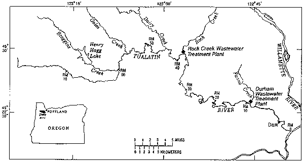