Columbia River Basalt Stratigraphy in the Pacific Northwest |
In Cooperation with the Oregon Water Resources Department |
| Skip site navigation bar and go to main content
CRBR Stratigraphic Nomenclature Chart Importance of Understanding CRBG Stratigraphy Contact |
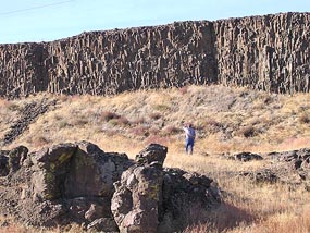
BackgroundAlthough CRBG eruptive activity spanned an 11-million-year period from 17 million to 6 million years ago, most of the CRBG flows were emplaced over 2.5 million years, from 17 to 14.5 million years ago (Swanson and others, 1979; Tolan and others, 1989). The basalt lava issued from fissures and vents in eastern Over 300 flows have been identified, and at least 20 made their way through the The CRBG is an important regional aquifer system, and in its folded and faulted flows, it records the late Cenozoic structural evolution of much of the Recognizing the stratigraphy of the CRBG is key to understanding deformation rates and internal structure of the aquifer. Although monotonous at first glance, flow packages, and in some cases individual flows, can be distinguished using subtle variations in appearance, chemical composition, and paleomagnetic direction. Field mapping, subsurface well logs and samples, aeromagnetic surveys, paleomagnetic and geochemical studies, and well testing are used to document individual flows, their distribution, deformation, and permeability. References Reidel, S.P., Fecht, K.R., Hagood, M.C., and Tolan, T.L., 1989, The geologic evolution of the central Columbia Plateau, in Reidel, S.P., and Hooper, P.R., eds., Volcanism and tectonism in the Columbia River flood-basalt province: Geological Society of America Special Paper 239, p. 247-264. Swanson, D.A., Wright, T.L., Hooper, P.R., and Bentley, R.D., 1979, Revision in the stratigraphic nomenclature of the Columbia River Basalt Group: U.S. Geological Survey Bulletin 1457-G, 59 p. Tolan, T.L., Reidel, S.P., Beeson, M.H., Anderson, J.L., Fecht, K.R., and Swanson, D.A., 1989, Revisions to the estimates of the areal extent and volume of the Columbia River Basalt Group, in Reidel, S.P., and Hooper, P.R., eds., Volcanism and tectonism in the Columbia River flood-basalt province: Geological Society of America Special Paper 239, p. 1-20. |
|
|
|
|
Oregon Water Science Center Studies Page Oregon Water Science Center Home Page |
![]() U.S. Department of the Interior |
U.S. Geological Survey
U.S. Department of the Interior |
U.S. Geological Survey
URL: https://or.water.usgs.gov/projs_dir/crbg/background.html
Page Contact Information: Oregon Webteam
Page Last Modified: Thursday, 15-Dec-2016 19:26:57 EST