Oregon Water Science Center
Hydrological Information to Support the Off-Project Water Program of the Klamath Basin Restoration AgreementIn Cooperation with the Klamath Tribes Contact: Daniel Snyder or Marshall Gannett 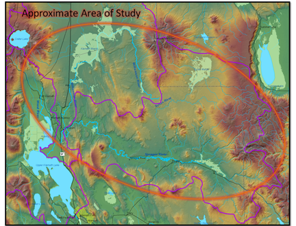
The study area encompasses most of the drainage basins for the northern tributaries to Upper Klamath Lake. SummaryThe Klamath Basin Restoration Agreement (KBRA) was developed by a diverse group of stakeholders, Federal and State resource management agencies, Tribal representatives, and interest groups to provide a comprehensive solution to ecological and water-supply issues in the Klamath Basin. The Off-Project Water Program (OPWP), one component of the KBRA, has as one of its purposes to permanently provide an additional 30,000 acre-feet of water per year on an average annual basis to Upper Klamath Lake through “voluntary retirement of water rights or water uses or other means as agreed to by the Klamath Tribes, to improve fisheries habitat and also provide for stability of irrigation water deliveries.” The geographic area where the water rights could be retired encompasses approximately 1,900 square miles. The OPWP area is defined as including the Sprague River drainage, the Sycan River drainage downstream of Sycan Marsh, the Wood River drainage, and the Williamson River drainage from Kirk Reef at the southern end of Klamath Marsh downstream to the confluence with the Sprague River. Extensive, broad, flat, poorly drained uplands, valleys, and wetlands characterize much of the study area. Irrigation is almost entirely used for pasture. To assist parties involved with decisionmaking and implementation of the OPWP, the U.S. Geological Survey (USGS), in cooperation with the Klamath Tribes and other stakeholders, created five hydrological information products. These products include GIS digital maps and datasets containing spatial information on evapotranspiration, subirrigation indicators, water rights, subbasin streamflow statistics, and return-flow indicators. The evapotranspiration (ET) datasets were created under contract for this study by Evapotranspiration, Plus, LLC, of Twin Falls, Idaho. A high-resolution remote sensing technique known as Mapping Evapotranspiration at High Resolution and Internalized Calibration (METRIC) was used to create estimates of the spatial distribution of ET. The METRIC technique uses thermal infrared Landsat imagery to quantify actual evapotranspiration at a 30-meter resolution that can be related to individual irrigated fields. Because evaporation uses heat energy, ground surfaces with large ET rates are left cooler as a result of ET than ground surfaces that have less ET. As a consequence, irrigated fields appear in the Landsat images as cooler than nonirrigated fields. Products produced from this study include total seasonal and total monthly (April–October) actual evapotranspiration maps for 2004 (a dry year) and 2006 (a wet year). Maps showing indicators of natural subirrigation were also provided by this study. “Subirrigation” as used here is the evapotranspiration of shallow groundwater by plants with roots that penetrate to or near the water table. Subirrigation often occurs at locations where the water table is at or above the plant rooting depth. Natural consumptive use by plants diminishes the benefit of retiring water rights in subirrigated areas. Some agricultural production may be possible, however, on subirrigated lands for which water rights are retired. Because of the difficulty in precisely mapping and quantifying subirrigation, this study presents several sources of spatially mapped data that can be used as indicators of higher subirrigation probability. These include the floodplain boundaries defined by stream geomorphology, water-table depth defined in Natural Resources Conservation Service (NRCS) soil surveys, and soil rooting depth defined in NRCS soil surveys. The two water-rights mapping products created in the study were “points of diversion” (POD) and “place of use” (POU) for surface-water irrigation rights. To create these maps, all surface-water rights data, decrees, certificates, permits, and unadjudicated claims within the entire 1,900 square mile study area were aggregated into a common GIS geodatabase. Surface-water irrigation rights within a 5-mile buffer of the study area were then selected and identified. The POU area was then totaled by water right for primary and supplemental water rights. The maximum annual volume (acre-feet) allowed under each water right also was calculated using the POU area and duty (allowable annual irrigation application in feet). In cases where a water right has more than one designated POD, the total volume for the water right was equally distributed to each POD listed for the water right. Because of this, mapped distribution of diversion rates for some rights may differ from actual practice. Water-right information in the map products was from digital datasets obtained from the Oregon Water Resources Department and was, at the time acquired, the best available compilation of water-right information available. Because the completeness and accuracy of the water-right data could not be verified, users are encouraged to check directly with the Oregon Water Resources Department where specific information on individual rights or locations is essential. A dataset containing streamflow statistics for 72 subbasins in the study area was created for the study area. The statistics include annual flow durations (5-, 10-, 25-, 50-, and 95-percent exceedances) and 7-day, 10-year (7Q10) and 7-day, 2-year (7Q2) low flows, and were computed using regional regression equations based on measured streamflow records in the region. Daily streamflow records used were adjusted as needed for crop consumptive use; therefore the statistics represent streamflow under more natural conditions as though irrigation diversions did not exist. Statistics are provided for flow rates resulting from streamflow originating from within the entire drainage area upstream of the subbasin pour point (referring to the outlet of the contributing drainage basin). The statistics were computed for the purpose of providing decision makers with the ability to estimate streamflow that would be expected after water conservation techniques have been implemented or a water right has been retired. A final product from the study are datasets of indicators of the potential for subsurface return flow of irrigation water from agricultural areas to nearby streams. The datasets contain information on factors such as proximity to surface-water features, geomorphic floodplain characteristics, and depth to water. The digital data, metadata, and example illustrations for the datasets described in this report are available on-line from the USGS Water Resources National Spatial Data Infrastructure (NSDI) Node Website http://water.usgs.gov/lookup/getgislist or from the U.S. Government website DATA.gov at http://www.data.gov with links provided in a Microsoft® Excel® workbook in appendix A of the project report. ObjectivesThe broad goal of the work described here is to develop information products that will be helpful to the parties involved in implementing the Off-Project Water Program. The following objectives are each intended to provide information products that are potentially useful towards that goal.
ApproachThe Klamath Basin Restoration Agreement sets an 18-month window after the effective date for development of a proposed Off-Project Water Settlement. There is interest on the part of the Klamath Watershed Partnership (and others) in having a decision making process in place before this time line. A two-phase approach is proposed. The first phase includes compilation and evaluation of relevant existing work and data in the upper basin, and synthesizing that information into a set of information products designed to specifically inform decision making. Critical data gaps and monitoring needs will also be identified as part of the first phase. Should efforts continue, a second phase could be developed to implement a monitoring program to evaluate the level of success of the first phase, and to address additional information needs. Phase 1 approaches to the numbered objectives listed above are as follows:
Relevance and BenefitsThe proposed study addresses key components of one of the six science directions of the USGS strategic science plan (USGS, 2007)―A Water Census of the United States―which includes the following need: “Promulgate the systematic definition and mapping of land-cover and land-use change for the United States on a continuous basis, to better understand how land- cover and land-use change are related to water quantity, quality, and use for human and environmental needs. Use time-series of land-cover and land-use data, climate data, water-use data, and hydrologic data to demonstrate how changes in land use, land-use practices, climate, and water use have resulted in changes in the availability and quality of water resources. Such studies are crucial to the validation of predictive models of how future decisions will affect water resources.”The results from this study will be directly relevant to the Bureau of Reclamation, U.S. Fish & Wildlife Service, and other agencies as they explore strategies to meet the water demands of the region. Publications and Example Maps
Click on the report cover image to obtain a full-sized cover image with links to various map types. Additional Example Maps
|
![]() U.S. Department of the Interior |
U.S. Geological Survey
U.S. Department of the Interior |
U.S. Geological Survey
URL: https://or.water.usgs.gov/projs_dir/Klamath_off_project/index.html
Page Contact Information: Oregon Webteam
Page Last Modified: Tuesday, 20-Dec-2016 16:33:20 EST

